![](/images/other/stat-length.png)
![Randonnée Marche Unknown - Ecosse - Jour 7 / V2 - Photo](https://media.geolcdn.com/t/1900/400/ext.pjpeg?maxdim=2&url=https%3A%2F%2Fmedia.geolcdn.com%2Ff%2F9a12cbb2-0500-45b9-98c9-be7362446163.jpg)
Ecosse - Jour 7 / V2
Greg813
Utilisateur
![Longueur](/images/other/stat-length.png)
Longueur
23 km
![Altitude max](https://static1.geolcdn.com/siteimages/upload/files/1508320355ic_sort_altitude_max_24dp.png)
Altitude max
37 m
![Dénivelé positif](https://static1.geolcdn.com/siteimages/upload/files/1508320355ic_sort_den_pos_24dp.png)
Dénivelé positif
145 m
![Km-Effort](/images/other/stat-length.png)
Km-Effort
25 km
![Altitude min](https://static1.geolcdn.com/siteimages/upload/files/1508320355ic_sort_altitude_min_24dp.png)
Altitude min
-2 m
![Dénivelé négatif](https://static1.geolcdn.com/siteimages/upload/files/1508320355ic_sort_den_neg_24dp.png)
Dénivelé négatif
155 m
![Boucle](https://static1.geolcdn.com/siteimages/upload/files/16400158638029165_repeat_loop_refresh_sync_direction_icon.png)
Boucle
Non
Date de création :
2022-12-03 17:00:24.177
Dernière modification :
2023-01-22 18:50:09.941
![Marche](https://static1.geolcdn.com/sitytour/trail-icons/101.png)
5h45
Difficulté : Difficile
![Scannez ce code QR pour ouvrir la randonnée dans l'application SityTrail](https://capi.geolives.com/qq0zvz2zws4bq2lad0pu/sitytour/trails/3473046/qr.png?size=200)
Application GPS de randonnée GRATUITE
À propos
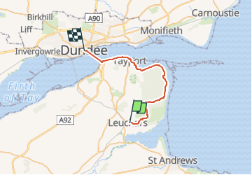
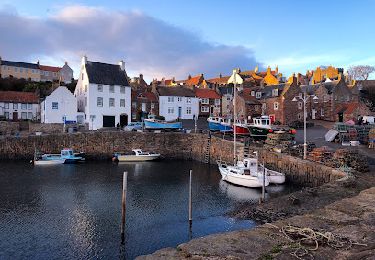
Randonnée Marche de 23 km à découvrir à Écosse, Fife. Cette randonnée est proposée par Greg813.
Description
De St Andrews (Hébergement en mobile home Cairnsmill Caravan Park), navette en bus (ligne 92D - station Hopital St Andrews) jusqu'à Leuchars.
Rando jusqu'à Dundee (Hébergement en dur au Dundee Backpackers Hostel)
Localisation
Pays :
Royaume-Uni
Région :
Écosse
Département/Province :
Fife
Commune :
Unknown
Localité :
Unknown
Départ:(Dec)
Départ:(UTM)
507489 ; 6248569 (30V) N.
Commentaires
Randonnées à proximité
![Randonnée Marche - Ecosse - Jour 6 / V2 - Photo](https://media.geolcdn.com/t/375/260/ext.jpg?maxdim=2&url=https%3A%2F%2Fmedia.geolcdn.com%2Ff%2F3e7f60d2-2fd0-4931-9395-b87d56391c4d.jpg)
![Marche Marche](https://static1.geolcdn.com/sitytour/trail-icons/101.png)
Ecosse - Jour 6 / V2
Marche
Facile
,
Écosse,
Fife,
Royaume-Uni
![](/images/other/stat-length.png)
14,9 km | 17,5 km-effort
3h 43min
![](https://static1.geolcdn.com/siteimages/upload/files/16400158638029165_repeat_loop_refresh_sync_direction_icon.png)
Non
![Randonnée Marche - Ecosse - Jour 4 / V2 - Photo](https://media.geolcdn.com/t/375/260/ext.jpg?maxdim=2&url=https%3A%2F%2Fmedia.geolcdn.com%2Ff%2Fbe86afe1-33f4-4b35-9587-d584b3d95226.jpg)
![Marche Marche](https://static1.geolcdn.com/sitytour/trail-icons/101.png)
Ecosse - Jour 4 / V2
Marche
Très difficile
,
Écosse,
Fife,
Royaume-Uni
![](/images/other/stat-length.png)
24 km | 26 km-effort
6h 0min
![](https://static1.geolcdn.com/siteimages/upload/files/16400158638029165_repeat_loop_refresh_sync_direction_icon.png)
Non
![Randonnée Marche - Ecosse - Jour 5 / V2 - Photo](https://media.geolcdn.com/t/375/260/ext.jpg?maxdim=2&url=https%3A%2F%2Fmedia.geolcdn.com%2Ff%2Fc0445ea1-7f38-40c1-8026-fba76bdb5d3b.jpg)
![Marche Marche](https://static1.geolcdn.com/sitytour/trail-icons/101.png)
![Randonnée Moteur - 012 St Andrews Rosyth - Photo](https://media.geolcdn.com/t/375/260/ext.jpg?maxdim=2&url=https%3A%2F%2Fstatic1.geolcdn.com%2Fsiteimages%2Fupload%2Ffiles%2F15247431544x4.jpg)
![Moteur Moteur](https://static1.geolcdn.com/sitytour/trail-icons/400.png)
012 St Andrews Rosyth
Moteur
Très facile
,
Écosse,
Fife,
Royaume-Uni
![](/images/other/stat-length.png)
86 km | 100 km-effort
Inconnu
![](https://static1.geolcdn.com/siteimages/upload/files/16400158638029165_repeat_loop_refresh_sync_direction_icon.png)
Non