Randonnée Marche Ulmen - Endert hike - Photo
 MathieuBourgois
MathieuBourgois

Utilisateur

© OpenStreetMap contributors
Longueur
Longueur
21 km
Altitude max
Altitude max
506 m
Dénivelé positif
Dénivelé positif
304 m
Km-Effort
Km-Effort  
26 km
Altitude min
Altitude min
82 m
Dénivelé négatif
Dénivelé négatif
650 m
Boucle
Boucle
Non
Date de création :
2022-12-08 07:43:01.222
Dernière modification :
2022-12-08 07:43:24.253

(0 Avis)

Marche
Marche
5h58
Difficulté : Très difficile

Scannez ce code QR pour ouvrir la randonnée dans l'application SityTrail

Application GPS de randonnée GRATUITE

Logo SityTrail SityTrail

IGN / Instituts géographiques

Télécharger SityTrail sur l'App Store Télécharger SityTrail sur Google Play

Logo SityTrail SityTrail World

Le monde est à vous

Télécharger SityTrail sur l'App Store Télécharger SityTrail sur Google Play Télécharger SityTrail sur Huawei AppGallery

À propos

Randonnée Marche de 21 km à découvrir à Rhénanie-Palatinat, Landkreis Cochem-Zell, Ulmen. Cette randonnée est proposée par MathieuBourgois.

Description

21km 300D   650 D-

Profil altimétrique

Localisation

Pays :
Allemagne
Région :
Rhénanie-Palatinat
Département/Province :
Landkreis Cochem-Zell
Commune :
Ulmen
Localité :
Unknown
Départ:(UTM)
355886 ; 5563885 (32U) N.

Randonnées à proximité

Randonnée A pied Steineberg - HeimatSpur Keltenrundweg - Photo
A pied
PRO

A pied

Moyen
Steineberg, Rhénanie-Palatinat, Landkreis Vulkaneifel, Allemagne
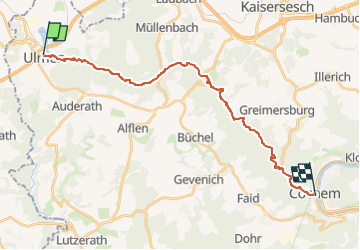
15,4 km | 20 km-effort
4h 36min
Oui
Randonnée A pied Alflen - Wilde Endert, Zuweg Alflen - Photo
A pied
PRO

A pied

Facile
Alflen, Rhénanie-Palatinat, Landkreis Cochem-Zell, Allemagne
3,1 km | 3,6 km-effort
49min
Non
Randonnée A pied Alflen - Wacholder Endert Pfad - Photo
A pied
PRO

A pied

Facile
Alflen, Rhénanie-Palatinat, Landkreis Cochem-Zell, Allemagne
10,1 km | 12,9 km-effort
2h 56min
Oui


Fermer
Mes abonnements