![](/images/other/stat-length.png)
![Randonnée Marche Castelnau-Durban - Castelnau Durban , Monseron par Lazon et retour - Photo](https://media.geolcdn.com/t/1900/400/ext.pjpeg?maxdim=2&url=https%3A%2F%2Fstatic1.geolcdn.com%2Fsiteimages%2Fupload%2Ffiles%2F1553511878bg_sport_marche.png)
Castelnau Durban , Monseron par Lazon et retour
Jean-Paul Raton
Utilisateur
![Longueur](/images/other/stat-length.png)
Longueur
6,7 km
![Altitude max](https://static1.geolcdn.com/siteimages/upload/files/1508320355ic_sort_altitude_max_24dp.png)
Altitude max
543 m
![Dénivelé positif](https://static1.geolcdn.com/siteimages/upload/files/1508320355ic_sort_den_pos_24dp.png)
Dénivelé positif
272 m
![Km-Effort](/images/other/stat-length.png)
Km-Effort
10,3 km
![Altitude min](https://static1.geolcdn.com/siteimages/upload/files/1508320355ic_sort_altitude_min_24dp.png)
Altitude min
391 m
![Dénivelé négatif](https://static1.geolcdn.com/siteimages/upload/files/1508320355ic_sort_den_neg_24dp.png)
Dénivelé négatif
274 m
![Boucle](https://static1.geolcdn.com/siteimages/upload/files/16400158638029165_repeat_loop_refresh_sync_direction_icon.png)
Boucle
Oui
Date de création :
2022-12-19 15:06:29.855
Dernière modification :
2022-12-19 15:16:26.418
![Marche](https://static1.geolcdn.com/sitytour/trail-icons/101.png)
2h20
Difficulté : Moyen
![Scannez ce code QR pour ouvrir la randonnée dans l'application SityTrail](https://capi.geolives.com/qq0zvz2zws4bq2lad0pu/sitytour/trails/3485992/qr.png?size=200)
Application GPS de randonnée GRATUITE
À propos
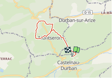
Randonnée Marche de 6,7 km à découvrir à Occitanie, Ariège, Castelnau-Durban. Cette randonnée est proposée par Jean-Paul Raton.
Description
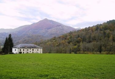
départ de Castelnau Durban ,nous montons vers Monseron en passant par la ferme de Lazon; on fait le tour de Monseron avec une jolie vue sur le chateau st Barthelemi, de Durban puis retour par le même chemin. 6kms700 et 270 mètres de dénivelé.
Localisation
Pays :
France
Région :
Occitanie
Département/Province :
Ariège
Commune :
Castelnau-Durban
Localité :
Unknown
Départ:(Dec)
Départ:(UTM)
364849 ; 4762578 (31T) N.
Commentaires
Randonnées à proximité
![Randonnée Vélo électrique Castelnau-Durban - Castelnau Durban à Niaux - Photo](https://media.geolcdn.com/t/375/260/ext.jpg?maxdim=2&url=https%3A%2F%2Fmedia.geolcdn.com%2Ff%2F3634c15e-87a5-45e8-ad04-4341a035c5d7.jpg)
![Vélo électrique Vélo électrique](https://static1.geolcdn.com/sitytour/trail-icons/205.png)
Castelnau Durban à Niaux
Vélo électrique
Moyen
Castelnau-Durban,
Occitanie,
Ariège,
France
![](/images/other/stat-length.png)
52 km | 63 km-effort
3h 8min
![](https://static1.geolcdn.com/siteimages/upload/files/16400158638029165_repeat_loop_refresh_sync_direction_icon.png)
Non
![Randonnée V.T.T. La Bastide-de-Sérou - segalas la bouiche et retour - Photo](https://media.geolcdn.com/t/375/260/ext.jpg?maxdim=2&url=https%3A%2F%2Fservices.sitytrail.com%2FGeolivesWS%2FDownloadMedia.ashx%3FTrailID%3D218527%26Media%3Dfix__20130902121734.jpg)
![V.T.T. V.T.T.](https://static1.geolcdn.com/sitytour/trail-icons/202.png)
segalas la bouiche et retour
V.T.T.
Facile
La Bastide-de-Sérou,
Occitanie,
Ariège,
France
![](/images/other/stat-length.png)
36 km | 42 km-effort
2h 47min
![](https://static1.geolcdn.com/siteimages/upload/files/16400158638029165_repeat_loop_refresh_sync_direction_icon.png)
Non
![Randonnée Cheval Allières - Allières - Les Cabesses - Photo](https://media.geolcdn.com/t/375/260/ext.jpg?maxdim=2&url=https%3A%2F%2Fservices.sitytrail.com%2FGeolivesWS%2FDownloadMedia.ashx%3FTrailID%3D108250%26Media%3D892_1.jpg)
![Cheval Cheval](https://static1.geolcdn.com/sitytour/trail-icons/300.png)
Allières - Les Cabesses
Cheval
Difficile
Allières,
Occitanie,
Ariège,
France
![](/images/other/stat-length.png)
28 km | 43 km-effort
2h 30min
![](https://static1.geolcdn.com/siteimages/upload/files/16400158638029165_repeat_loop_refresh_sync_direction_icon.png)
Non
![Randonnée Cheval La Bastide-de-Sérou - Chemin de St Jacques - Mondely - Montjoie - Photo](https://media.geolcdn.com/t/375/260/ext.jpg?maxdim=2&url=https%3A%2F%2Fservices.sitytrail.com%2FGeolivesWS%2FDownloadMedia.ashx%3FTrailID%3D108242%26Media%3D884_1.jpg)
![Cheval Cheval](https://static1.geolcdn.com/sitytour/trail-icons/300.png)
Chemin de St Jacques - Mondely - Montjoie
Cheval
Très difficile
La Bastide-de-Sérou,
Occitanie,
Ariège,
France
![](/images/other/stat-length.png)
28 km | 39 km-effort
3h 15min
![](https://static1.geolcdn.com/siteimages/upload/files/16400158638029165_repeat_loop_refresh_sync_direction_icon.png)
Non
![Randonnée Cheval Clermont - Boucle dans le Massif de l'Arize - Clermont - Lescure - Photo](https://media.geolcdn.com/t/375/260/ext.jpg?maxdim=2&url=https%3A%2F%2Fservices.sitytrail.com%2FGeolivesWS%2FDownloadMedia.ashx%3FTrailID%3D108216%26Media%3D854_1.jpg)
![Cheval Cheval](https://static1.geolcdn.com/sitytour/trail-icons/300.png)
Boucle dans le Massif de l'Arize - Clermont - Lescure
Cheval
Moyen
Clermont,
Occitanie,
Ariège,
France
![](/images/other/stat-length.png)
9,6 km | 13,1 km-effort
1h 0min
![](https://static1.geolcdn.com/siteimages/upload/files/16400158638029165_repeat_loop_refresh_sync_direction_icon.png)
Non
![Randonnée Cheval Allières - Boucle dans le Massif de l'Arize - Allières - Clermont - Photo](https://media.geolcdn.com/t/375/260/ext.jpg?maxdim=2&url=https%3A%2F%2Fservices.sitytrail.com%2FGeolivesWS%2FDownloadMedia.ashx%3FTrailID%3D108215%26Media%3D853_1.jpg)
![Cheval Cheval](https://static1.geolcdn.com/sitytour/trail-icons/300.png)
Boucle dans le Massif de l'Arize - Allières - Clermont
Cheval
Moyen
Allières,
Occitanie,
Ariège,
France
![](/images/other/stat-length.png)
8,1 km | 12 km-effort
1h 0min
![](https://static1.geolcdn.com/siteimages/upload/files/16400158638029165_repeat_loop_refresh_sync_direction_icon.png)
Non
![Randonnée Marche Le Mas-d'Azil - Capes Baluet, Cap de Pralou sur le chemin de Compostelle - Photo](https://media.geolcdn.com/t/375/260/ext.jpg?maxdim=2&url=https%3A%2F%2Fstatic1.geolcdn.com%2Fsiteimages%2Fupload%2Ffiles%2F1553511878bg_sport_marche.png)
![Marche Marche](https://static1.geolcdn.com/sitytour/trail-icons/101.png)
Capes Baluet, Cap de Pralou sur le chemin de Compostelle
Marche
Facile
Le Mas-d'Azil,
Occitanie,
Ariège,
France
![](/images/other/stat-length.png)
3,6 km | 5,4 km-effort
1h 13min
![](https://static1.geolcdn.com/siteimages/upload/files/16400158638029165_repeat_loop_refresh_sync_direction_icon.png)
Non
![Randonnée Marche Durban-sur-Arize - Château de Saint Barthélemy - Photo](https://media.geolcdn.com/t/375/260/ext.jpg?maxdim=2&url=https%3A%2F%2Fstatic1.geolcdn.com%2Fsiteimages%2Fupload%2Ffiles%2F1553511878bg_sport_marche.png)
![Marche Marche](https://static1.geolcdn.com/sitytour/trail-icons/101.png)
Château de Saint Barthélemy
Marche
Moyen
Durban-sur-Arize,
Occitanie,
Ariège,
France
![](/images/other/stat-length.png)
3,6 km | 5,7 km-effort
50min
![](https://static1.geolcdn.com/siteimages/upload/files/16400158638029165_repeat_loop_refresh_sync_direction_icon.png)
Non
![Randonnée Marche Durban-sur-Arize - Autour du château de Saint Barthélémy - Photo](https://media.geolcdn.com/t/375/260/ext.jpg?maxdim=2&url=https%3A%2F%2Fstatic1.geolcdn.com%2Fsiteimages%2Fupload%2Ffiles%2F1553511878bg_sport_marche.png)
![Marche Marche](https://static1.geolcdn.com/sitytour/trail-icons/101.png)
Autour du château de Saint Barthélémy
Marche
Moyen
Durban-sur-Arize,
Occitanie,
Ariège,
France
![](/images/other/stat-length.png)
13,1 km | 19,3 km-effort
3h 57min
![](https://static1.geolcdn.com/siteimages/upload/files/16400158638029165_repeat_loop_refresh_sync_direction_icon.png)
Oui