


challenge rando Ascegee

Tommy Eric
Utilisateur
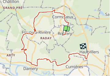

Longueur
19,4 km

Altitude max
274 m

Dénivelé positif
480 m
Km-Effort
26 km

Altitude min
77 m

Dénivelé négatif
445 m
Boucle
Non
Date de création :
2023-02-09 09:21:46.034
Dernière modification :
2023-02-09 14:23:58.008
4h03
Difficulté : Très difficile

Application GPS de randonnée GRATUITE
 SityTrail
IGN / Instituts géographiques
SityTrail Plus
Le monde est à vous
À propos
Randonnée Marche de 19,4 km à découvrir à Grand Est, Marne, Romery. Cette randonnée est proposée par Tommy Eric.
Localisation
Pays :
France
Région :
Grand Est
Département/Province :
Marne
Commune :
Romery
Localité :
Unknown
Départ:(Dec)
Départ:(UTM)
566657 ; 5438451 (31U) N.
Commentaires