Randonnée Marche Westhalten - 68 Westhalten - Strangenberg - Restaurant Better - Photo

68 Westhalten - Strangenberg - Restaurant Better

 E.BURCK
E.BURCK

Utilisateur

© OpenStreetMap contributors
Longueur
Longueur
10,4 km
Altitude max
Altitude max
470 m
Dénivelé positif
Dénivelé positif
323 m
Km-Effort
Km-Effort  
14,7 km
Altitude min
Altitude min
226 m
Dénivelé négatif
Dénivelé négatif
327 m
Boucle
Boucle
Oui
Date de création :
2023-03-01 09:45:10.673
Dernière modification :
2023-03-01 09:47:50.758

(0 Avis)

Marche
Marche
3h20
Difficulté : Moyen

Scannez ce code QR pour ouvrir la randonnée dans l'application SityTrail

Application GPS de randonnée GRATUITE

Logo SityTrail SityTrail

IGN / Instituts géographiques

Télécharger SityTrail sur l'App Store Télécharger SityTrail sur Google Play

Logo SityTrail SityTrail World

Le monde est à vous

Télécharger SityTrail sur l'App Store Télécharger SityTrail sur Google Play Télécharger SityTrail sur Huawei AppGallery

À propos

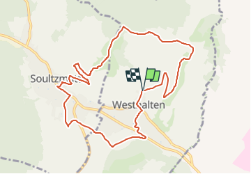
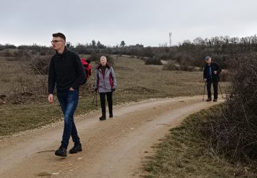
Randonnée Marche de 10,4 km à découvrir à Grand Est, Haut-Rhin, Westhalten. Cette randonnée est proposée par E.BURCK.

Description

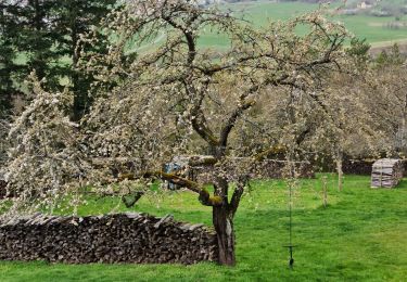
Aller à Soultzmatt par le Strangenberg. Puis, dans la descente vers le restaurant, nous devrions voir l'amandier en fleurs.   325m de dénivelé sur 10.5 km.
 
ACCÈS :    
- par la 83, direction Westhalten, prendre la rue à droite avant d'entrer dans le village. Prendre ensuite à droite la rue de l'église pour rejoindre le parking du cimetière.

PARKING:
à Westhalten près de l'église le parking derrière le cimetière..
47.960 ,                  7.261   ou        
N 47°57'36" ,    E  7°15'40"  
Restaurant:   Chez Better  Soultzmatt
Tél.: 03 89 47 00 13            

Profil altimétrique

Localisation

Pays :
France
Région :
Grand Est
Département/Province :
Haut-Rhin
Commune :
Westhalten
Localité :
Unknown
Départ:(Dec)
Départ:(UTM)
370156 ; 5313322 (32T) N.

Randonnées à proximité

Randonnée Marche Westhalten - 2021 03 04 Westhalten - Photo
Marche
E.BURCK

Marche

Facile
(1)
Westhalten, Grand Est, Haut-Rhin, France
7,7 km | 11,3 km-effort
2h 21min
Oui
Randonnée Marche Osenbach - Osenbach - Sentier des Sols - Photo
Marche
gscheven

Marche

Facile
(1)
Osenbach, Grand Est, Haut-Rhin, France
4,7 km | 6,6 km-effort
3h 0min
Oui
Randonnée Marche Rouffach - 68 Rouffach- Schauenberg variante
Marche
E.BURCK

Marche

Facile
(1)
Rouffach, Grand Est, Haut-Rhin, France
10,6 km | 15,3 km-effort
3h 29min
Oui
Randonnée Marche Westhalten - ND du Hubel_Schauenberg - Photo
Marche
dick68

Marche

Moyen
(2)
Westhalten, Grand Est, Haut-Rhin, France
8,3 km | 11,7 km-effort
2h 39min
Oui
Randonnée Marche Pfaffenheim - Schauenberg 1 - Photo
Marche
regisbodilis

Marche

Facile
(1)
Pfaffenheim, Grand Est, Haut-Rhin, France
10,3 km | 16,5 km-effort
3h 30min
Oui
Randonnée V.T.T. Westhalten - Westhalten - Le tour de la vallée Noble - Photo
V.T.T.
sit68000

V.T.T.

Difficile
(1)
Westhalten, Grand Est, Haut-Rhin, France
24 km | 33 km-effort
2h 30min
Oui
Randonnée Marche Westhalten - WESTHALTEN ZINKOEPHLE - Photo
Marche
MarcOBRECHT

Marche

Moyen
Westhalten, Grand Est, Haut-Rhin, France
10,6 km | 15,3 km-effort
2h 56min
Oui
Randonnée Marche Westhalten - Westhalten - Rouffach  - Photo
Marche
Richard68500

Marche

Difficile
Westhalten, Grand Est, Haut-Rhin, France
8,9 km | 13 km-effort
3h 22min
Oui
Randonnée Marche Soultzmatt - Rando du 30/03/2034 - Photo
Marche
boubou68

Marche

Difficile
Soultzmatt, Grand Est, Haut-Rhin, France
19,5 km | 29 km-effort
4h 32min
Oui


Fermer
Mes abonnements