


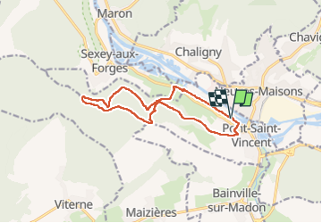
Pont St Vincent - Chemin des mines

noelphil
Utilisateur

Longueur
12,2 km

Altitude max
372 m

Dénivelé positif
242 m
Km-Effort
15,5 km

Altitude min
214 m

Dénivelé négatif
241 m
Boucle
Oui
Date de création :
2023-03-01 12:27:04.205
Dernière modification :
2023-03-02 07:16:49.923
3h21
Difficulté : Difficile

Application GPS de randonnée GRATUITE
 SityTrail
IGN / Instituts géographiques
SityTrail Plus
Le monde est à vous
À propos
Randonnée Marche de 12,2 km à découvrir à Grand Est, Meurthe-et-Moselle, Pont-Saint-Vincent. Cette randonnée est proposée par noelphil.
Photos

Localisation
Pays :
France
Région :
Grand Est
Département/Province :
Meurthe-et-Moselle
Commune :
Pont-Saint-Vincent
Localité :
Unknown
Départ:(Dec)
Départ:(UTM)
285725 ; 5388031 (32U) N.
Commentaires