


Vancelle enregistrer

MAD-CVW
Utilisateur

Longueur
27 km

Altitude max
159 m

Dénivelé positif
206 m
Km-Effort
29 km

Altitude min
92 m

Dénivelé négatif
175 m
Boucle
Non
Date de création :
2023-04-26 08:08:04.223
Dernière modification :
2023-05-22 19:31:44.989
633h53
Difficulté : Très difficile

Application GPS de randonnée GRATUITE
 SityTrail
IGN / Instituts géographiques
SityTrail Plus
Le monde est à vous
À propos
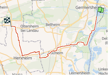
Randonnée Marche de 27 km à découvrir à Rhénanie-Palatinat, Landkreis Germersheim, Germersheim. Cette randonnée est proposée par MAD-CVW.
Localisation
Pays :
Allemagne
Région :
Rhénanie-Palatinat
Département/Province :
Landkreis Germersheim
Commune :
Germersheim
Localité :
Unknown
Départ:(Dec)
Départ:(UTM)
455222 ; 5450762 (32U) N.
Commentaires