Randonnée Marche Murbach - Murbach - Photo
 oscar1
oscar1

Utilisateur

© OpenStreetMap contributors
Longueur
Longueur
15,4 km
Altitude max
Altitude max
978 m
Dénivelé positif
Dénivelé positif
716 m
Km-Effort
Km-Effort  
25 km
Altitude min
Altitude min
430 m
Dénivelé négatif
Dénivelé négatif
717 m
Boucle
Boucle
Oui
Date de création :
2023-06-06 07:25:08.546
Dernière modification :
2023-06-07 19:21:51.268

(0 Avis)

Marche
Marche
4h25
Difficulté : Difficile

Scannez ce code QR pour ouvrir la randonnée dans l'application SityTrail

Application GPS de randonnée GRATUITE

Logo SityTrail SityTrail

IGN / Instituts géographiques

Télécharger SityTrail sur l'App Store Télécharger SityTrail sur Google Play

Logo SityTrail SityTrail World

Le monde est à vous

Télécharger SityTrail sur l'App Store Télécharger SityTrail sur Google Play Télécharger SityTrail sur Huawei AppGallery

À propos

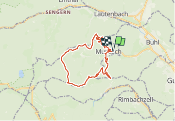
Randonnée Marche de 15,4 km à découvrir à Grand Est, Haut-Rhin, Murbach. Cette randonnée est proposée par oscar1.

Description

1 ère montée sur 3 kms environ relativement raide mais agréable à marcher. La seconde montée entre le 5 éme et 7 éme Km plus raide encore et caillouteux, d'où une marche compliquée. Néanmoins rien d'extraordinaire pour randonneurs aguerris. sinon très belle balade avec des points de vue.

Profil altimétrique

Photos

Localisation

Pays :
France
Région :
Grand Est
Département/Province :
Haut-Rhin
Commune :
Murbach
Localité :
Unknown
Départ:(UTM)
362595 ; 5309378 (32T) N.

Randonnées à proximité

Randonnée Marche Linthal - Tour de la grande Vallée de Munster (refuge du Hilsen - Munster) - Photo
Marche
tracegps

Marche

Difficile
(1)
Linthal, Grand Est, Haut-Rhin, France
18,1 km | 24 km-effort
5h 0min
Non
Randonnée Marche Lautenbachzell - Le Markstein - Photo
Marche
tracegps

Marche

Difficile
(1)
Lautenbachzell, Grand Est, Haut-Rhin, France
22 km | 35 km-effort
6h 0min
Oui
Randonnée A pied Goldbach-Altenbach - Firstacker - Willer sur Thur - Photo
A pied
PRO

A pied

Facile
Goldbach-Altenbach, Grand Est, Haut-Rhin, France
7,4 km | 9,6 km-effort
2h 11min
Non
Randonnée Marche Linthal - 68 Remspach - Hilsen - Photo
Marche

Marche

Moyen
(1)
Linthal, Grand Est, Haut-Rhin, France
9,9 km | 14,6 km-effort
3h 3min
Oui
Randonnée Marche Soultz-Haut-Rhin - Rando Marcheurs..04/04_2025 - Photo
Marche
boubou68

Marche

Très difficile
Soultz-Haut-Rhin, Grand Est, Haut-Rhin, France
21 km | 35 km-effort
4h 42min
Oui
Randonnée Marche Jungholtz - Rando Retrouvailles...01/03/2024.par Jean Marc - Photo
Marche
boubou68

Marche

Très difficile
Jungholtz, Grand Est, Haut-Rhin, France
11,3 km | 19,2 km-effort
1h 35min
Oui
Randonnée Marche Soultz-Haut-Rhin - Mon tour des Vosges (4 jours) - Photo
Marche
annefrance70

Marche

Très difficile
Soultz-Haut-Rhin, Grand Est, Haut-Rhin, France
71 km | 113 km-effort
25h 38min
Oui
Randonnée Marche Murbach - La
Marche
boubou68

Marche

Très difficile
Murbach, Grand Est, Haut-Rhin, France
14,7 km | 28 km-effort
4h 3min
Oui
Randonnée Marche Linthal - Hilsen-Petit Ballon-Hilsen - Photo
Marche
griffet

Marche

Moyen
Linthal, Grand Est, Haut-Rhin, France
9,5 km | 14,1 km-effort
3h 27min
Oui


Fermer
Mes abonnements