Randonnée Marche Mus - montreal du Gers-Ronceveaux - Photo

montreal du Gers-Ronceveaux

 sarah
sarah

Utilisateur

© OpenStreetMap contributors
Longueur
Longueur
1,1 km
Altitude max
Altitude max
49 m
Dénivelé positif
Dénivelé positif
10 m
Km-Effort
Km-Effort  
1,3 km
Altitude min
Altitude min
22 m
Dénivelé négatif
Dénivelé négatif
23 m
Boucle
Boucle
Non
Date de création :
2014-12-10 00:00:00.0
Dernière modification :
2014-12-10 00:00:00.0

(1 Avis)

Marche
Marche
--
Difficulté : Inconnu

Scannez ce code QR pour ouvrir la randonnée dans l'application SityTrail

Application GPS de randonnée GRATUITE

Logo SityTrail SityTrail

IGN / Instituts géographiques

Télécharger SityTrail sur l'App Store Télécharger SityTrail sur Google Play

Logo SityTrail SityTrail World

Le monde est à vous

Télécharger SityTrail sur l'App Store Télécharger SityTrail sur Google Play Télécharger SityTrail sur Huawei AppGallery

À propos

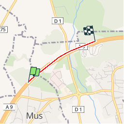
Randonnée Marche de 1,1 km à découvrir à Occitanie, Gard, Mus. Cette randonnée est proposée par sarah.

Profil altimétrique

Localisation

Pays :
France
Région :
Occitanie
Département/Province :
Gard
Commune :
Mus
Localité :
Unknown
Départ:(Dec)
Départ:(UTM)
596694 ; 4844280 (31T) N.

Commentaires

Veuillez vous connecter pour laisser un commentaire ou une note


Bon courage pour randonner en plain sur l'AUTOROUTE un Kilomètre si vous arrivez aux bout vous pouvez faire bruler un cierge a l'église il faut effacer ce tracée qui en est pas un


Randonnées à proximité

Randonnée V.T.T. Villetelle - Grande Traversée de l'Hérault à VTT - De Ambrussum à Fondespierre - Photo
V.T.T.
tracegps

V.T.T.

Moyen
(2)
Villetelle, Occitanie, Hérault, France
29 km | 33 km-effort
3h 30min
Non
Randonnée V.T.T. Calvisson - Espace VTT-FFC Pays de Sommières n°7 - Les Châteaux du Sommiérois - Photo
V.T.T.
tracegps

V.T.T.

Difficile
(1)
Calvisson, Occitanie, Gard, France
42 km | 50 km-effort
3h 30min
Oui
Randonnée Cheval Gallargues-le-Montueux - Aujargues - Photo
Cheval
N-Letessier

Cheval

Facile
(1)
Gallargues-le-Montueux, Occitanie, Gard, France
28 km | 32 km-effort
5h 33min
Oui
Randonnée Marche Congénies - congenies-lemazet-calvisson - Photo
Marche
v.rabot

Marche

Moyen
Congénies, Occitanie, Gard, France
16,9 km | 21 km-effort
5h 0min
Oui
Randonnée Marche Aubais - Aubais-junas-moulin_de_corbières - Photo
Marche
v.rabot

Marche

Moyen
Aubais, Occitanie, Gard, France
15,5 km | 18,3 km-effort
5h 0min
Oui
Randonnée Marche Aubais - moulin-carriere-gallargues - Photo
Marche
v.rabot

Marche

Facile
Aubais, Occitanie, Gard, France
12,5 km | 14,1 km-effort
2h 30min
Oui
Randonnée Marche Villetelle - Sensei pascal  - Photo
Marche
rio34740

Marche

Moyen
Villetelle, Occitanie, Hérault, France
17,7 km | 0 m-effort
5h 17min
Oui
Randonnée Marche Congénies - Congenies-Mazet-Sincans-Calvisson - Photo
Marche
v.rabot

Marche

Moyen
Congénies, Occitanie, Gard, France
18 km | 23 km-effort
5h 30min
Oui
Randonnée Marche Aubais - aubais-junas-moulin de corbières - Photo
Marche
v.rabot

Marche

Moyen
Aubais, Occitanie, Gard, France
16,8 km | 20 km-effort
5h 38min
Oui


Fermer
Mes abonnements