Randonnée Randonnée équestre Athis-Val-de-Rouvre - rando roches 29km - Photo
 Delphine Besace
Delphine Besace

Utilisateur

© OpenStreetMap contributors
Longueur
Longueur
29 km
Altitude max
Altitude max
276 m
Dénivelé positif
Dénivelé positif
551 m
Km-Effort
Km-Effort  
37 km
Altitude min
Altitude min
97 m
Dénivelé négatif
Dénivelé négatif
544 m
Boucle
Boucle
Oui
Date de création :
2023-09-02 20:50:02.66
Dernière modification :
2023-09-02 20:50:03.978

(0 Avis)

Randonnée équestre
Randonnée équestre
4h49
Difficulté : Difficile

Scannez ce code QR pour ouvrir la randonnée dans l'application SityTrail

Application GPS de randonnée GRATUITE

Logo SityTrail SityTrail

IGN / Instituts géographiques

Télécharger SityTrail sur l'App Store Télécharger SityTrail sur Google Play

Logo SityTrail SityTrail World

Le monde est à vous

Télécharger SityTrail sur l'App Store Télécharger SityTrail sur Google Play Télécharger SityTrail sur Huawei AppGallery

À propos

Randonnée Randonnée équestre de 29 km à découvrir à Normandie, Orne, Athis-Val-de-Rouvre. Cette randonnée est proposée par Delphine Besace.

Profil altimétrique

Localisation

Pays :
France
Région :
Normandie
Département/Province :
Orne
Commune :
Athis-Val-de-Rouvre
Localité :
Notre-Dame-du-Rocher
Départ:(UTM)
690184 ; 5407205 (30U) N.

Randonnées à proximité

Randonnée Marche Saint-Philbert-sur-Orne - Autour des roches d'oetre - Photo
Marche
phi14

Marche

Facile
(3)
Saint-Philbert-sur-Orne, Normandie, Orne, France
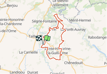
9,7 km | 12,4 km-effort
2h 30min
Oui
Randonnée Marche Athis-Val-de-Rouvre - Rando botanique  - Ségrie Fontaine  - Photo
Marche
tracegps

Marche

Moyen
(2)
Athis-Val-de-Rouvre, Normandie, Orne, France
10,4 km | 13,4 km-effort
3h 40min
Oui
Randonnée Marche Saint-Philbert-sur-Orne - Roche d’oëtre sentier du Granite - Photo
Marche
zefreefly

Marche

Très facile
Saint-Philbert-sur-Orne, Normandie, Orne, France
10,1 km | 12,7 km-effort
2h 43min
Oui
Randonnée Marche Saint-Philbert-sur-Orne - Circuit des méandres  - Photo
Marche
JLPIERSON

Marche

Moyen
Saint-Philbert-sur-Orne, Normandie, Orne, France
6,4 km | 8,4 km-effort
1h 54min
Oui
Randonnée A pied Athis-Val-de-Rouvre - Les Fontaines - Photo
A pied
PRO

A pied

Facile
Athis-Val-de-Rouvre, Normandie, Orne, France
5,7 km | 7,3 km-effort
1h 38min
Oui
Randonnée A pied Athis-Val-de-Rouvre - Sentier du granite - Photo
A pied
PRO

A pied

Facile
(1)
Athis-Val-de-Rouvre, Normandie, Orne, France
8,6 km | 11 km-effort
2h 30min
Oui
Randonnée Marche Saint-Philbert-sur-Orne - Wikiloc Roche d'Oetre (PVDB) - Photo
Marche
GUIDE
Peter.vdbergh

Marche

Moyen
Saint-Philbert-sur-Orne, Normandie, Orne, France
8,3 km | 10,8 km-effort
2h 48min
Oui
Randonnée Marche Saint-Philbert-sur-Orne - La roche d'oëtre - Le cul du Rouvre - Photo
Marche
PatRando

Marche

Moyen
Saint-Philbert-sur-Orne, Normandie, Orne, France
6,8 km | 8,7 km-effort
1h 36min
Oui
Randonnée Marche Saint-Philbert-sur-Orne - circuit des méandres  - Photo
Marche
ymarvin

Marche

Moyen
Saint-Philbert-sur-Orne, Normandie, Orne, France
6,3 km | 8,3 km-effort
1h 46min
Oui


Fermer
Mes abonnements