Randonnée Marche Dettey - charbonnat petite 7km7 - Photo
 JOSI71
JOSI71

Utilisateur

© OpenStreetMap contributors
Longueur
Longueur
7,6 km
Altitude max
Altitude max
449 m
Dénivelé positif
Dénivelé positif
99 m
Km-Effort
Km-Effort  
9,5 km
Altitude min
Altitude min
262 m
Dénivelé négatif
Dénivelé négatif
283 m
Boucle
Boucle
Non
Date de création :
2023-09-14 11:04:20.339
Dernière modification :
2023-09-14 13:44:26.01

(0 Avis)

Marche
Marche
2h39
Difficulté : Moyen

Scannez ce code QR pour ouvrir la randonnée dans l'application SityTrail

Application GPS de randonnée GRATUITE

Logo SityTrail SityTrail

IGN / Instituts géographiques

Télécharger SityTrail sur l'App Store Télécharger SityTrail sur Google Play

Logo SityTrail SityTrail World

Le monde est à vous

Télécharger SityTrail sur l'App Store Télécharger SityTrail sur Google Play Télécharger SityTrail sur Huawei AppGallery

À propos

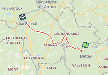
Randonnée Marche de 7,6 km à découvrir à Bourgogne-Franche-Comté, Saône-et-Loire, Dettey. Cette randonnée est proposée par JOSI71.

Description

l'aprem d'une grande

Profil altimétrique

Localisation

Pays :
France
Région :
Bourgogne-Franche-Comté
Département/Province :
Saône-et-Loire
Commune :
Dettey
Localité :
Unknown
Départ:(UTM)
589852 ; 5179966 (31T) N.

Randonnées à proximité

Randonnée Marche La Boulaye - LA BOULAYE - Photo
Marche
Bret

Marche

Moyen
(1)
La Boulaye, Bourgogne-Franche-Comté, Saône-et-Loire, France
9,4 km | 12,6 km-effort
2h 41min
Oui
Randonnée Marche Dettey -
Marche
LucThomaere

Marche

Difficile
Dettey, Bourgogne-Franche-Comté, Saône-et-Loire, France
14,1 km | 18,8 km-effort
4h 16min
Oui
Randonnée A pied La Tagnière - La Tagnière - Photo
A pied
Malice0093

A pied

Facile
La Tagnière, Bourgogne-Franche-Comté, Saône-et-Loire, France
11,3 km | 14,6 km-effort
3h 18min
Oui
Randonnée Marche La Tagnière - la tagniere grs 14-11 - Photo
Marche

Marche

Moyen
(1)
La Tagnière, Bourgogne-Franche-Comté, Saône-et-Loire, France
8 km | 9,9 km-effort
1h 49min
Oui
Randonnée sport Charbonnat - 2023-07-27_08h37m04_SityTrail - 3746717 - charbonnat-19 (1) - Photo
sport
Jacqueline Nouveau

sport

Très facile
(1)
Charbonnat, Bourgogne-Franche-Comté, Saône-et-Loire, France
18,7 km | 24 km-effort
Inconnu
Oui
Randonnée V.T.T. La Tagnière - La Tagniere Autun - Photo
V.T.T.
Carnzu

V.T.T.

Difficile
La Tagnière, Bourgogne-Franche-Comté, Saône-et-Loire, France
43 km | 58 km-effort
5h 0min
Non
Randonnée A pied Saint-Eugène - SAINT EUGENE - Photo
A pied
nollipap

A pied

Facile
Saint-Eugène, Bourgogne-Franche-Comté, Saône-et-Loire, France
12,6 km | 16,1 km-effort
3h 39min
Oui
Randonnée Marche Charbonnat - CHARBONNAT - Photo
Marche
nollipap

Marche

Difficile
Charbonnat, Bourgogne-Franche-Comté, Saône-et-Loire, France
11,7 km | 14,5 km-effort
3h 17min
Oui
Randonnée Marche Charbonnat - charbonnat plaije - Photo
Marche
fetievant

Marche

Très facile
Charbonnat, Bourgogne-Franche-Comté, Saône-et-Loire, France
17,9 km | 22 km-effort
4h 48min
Oui


Fermer
Mes abonnements