Randonnée  Nittel - Wikiloc - Moselsteig E03: Nittel bis Konz - Photo

Wikiloc - Moselsteig E03: Nittel bis Konz

 pasvraimec
pasvraimec

Utilisateur

© OpenStreetMap contributors
Longueur
Longueur
23 km
Altitude max
Altitude max
357 m
Dénivelé positif
Dénivelé positif
531 m
Km-Effort
Km-Effort  
30 km
Altitude min
Altitude min
128 m
Dénivelé négatif
Dénivelé négatif
538 m
Boucle
Boucle
Non
Date de création :
2023-12-12 19:27:35.405
Dernière modification :
2023-12-12 19:28:58.312

(0 Avis)


Scannez ce code QR pour ouvrir la randonnée dans l'application SityTrail

Application GPS de randonnée GRATUITE

Logo SityTrail SityTrail

IGN / Instituts géographiques

Télécharger SityTrail sur l'App Store Télécharger SityTrail sur Google Play

Logo SityTrail SityTrail World

Le monde est à vous

Télécharger SityTrail sur l'App Store Télécharger SityTrail sur Google Play Télécharger SityTrail sur Huawei AppGallery

À propos

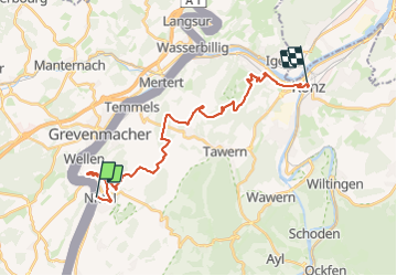
Randonnée de 23 km à découvrir à Rhénanie-Palatinat, Landkreis Trier-Saarburg, Nittel. Cette randonnée est proposée par pasvraimec.

Profil altimétrique

Localisation

Pays :
Allemagne
Région :
Rhénanie-Palatinat
Département/Province :
Landkreis Trier-Saarburg
Commune :
Nittel
Localité :
Unknown
Départ:(UTM)
315312 ; 5503312 (32U) N.

Randonnées à proximité

Randonnée A pied Wormeldange - Traumschleife Wein- und Naturpfad Palmberg Ahn - Photo
A pied
PRO

A pied

Facile
Wormeldange, Inconnu, Canton Grevenmacher, Luxembourg
8,9 km | 13 km-effort
2h 57min
Oui
Randonnée A pied Mannebach - 3-Dörfer-Weg - Photo
A pied
PRO

A pied

Moyen
Mannebach, Rhénanie-Palatinat, Landkreis Trier-Saarburg, Allemagne
17,1 km | 23 km-effort
5h 11min
Oui
Randonnée A pied Mannebach - Mannebach 111 - Photo
A pied
PRO

A pied

Facile
Mannebach, Rhénanie-Palatinat, Landkreis Trier-Saarburg, Allemagne
12 km | 17,1 km-effort
3h 53min
Oui
Randonnée A pied Grevenmacher - FB Grevenmacher I - Photo
A pied
PRO

A pied

Facile
Grevenmacher, Inconnu, Canton Grevenmacher, Luxembourg
6,5 km | 9,1 km-effort
2h 3min
Oui
Randonnée A pied Wormeldange - auto-pedestre Wormeldange - Photo
A pied
PRO

A pied

Facile
Wormeldange, Inconnu, Canton Grevenmacher, Luxembourg
5,1 km | 6,5 km-effort
1h 28min
Oui
Randonnée A pied Wormeldange - rambling route Machtum 1 - Photo
A pied
PRO

A pied

Facile
Wormeldange, Inconnu, Canton Grevenmacher, Luxembourg
7,5 km | 10,7 km-effort
2h 25min
Oui
Randonnée A pied Grevenmacher - Fleche Bleu Grevenmacher II - Photo
A pied
PRO

A pied

Facile
Grevenmacher, Inconnu, Canton Grevenmacher, Luxembourg
5,1 km | 6,7 km-effort
1h 30min
Oui
Randonnée Marche Wormeldange - Kelsbaach - Photo
Marche
GUIDE+

Marche

Très facile
Wormeldange, Inconnu, Canton Grevenmacher, Luxembourg
5,2 km | 7,6 km-effort
Inconnu
Non
Randonnée V.T.T. Flaxweiler - Pistes_VTT : Wormeldange VTT/MTB - Photo
V.T.T.
GUIDE+

V.T.T.

Très facile
Flaxweiler, Inconnu, Canton Grevenmacher, Luxembourg
24 km | 31 km-effort
Inconnu
Oui


Fermer
Mes abonnements