


Floreffe DEPS

thomarche
Utilisateur
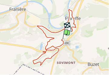

Longueur
9,5 km

Altitude max
193 m

Dénivelé positif
180 m
Km-Effort
12,1 km

Altitude min
82 m

Dénivelé négatif
243 m
Boucle
Non
Date de création :
2024-01-28 12:11:21.0
Dernière modification :
2024-01-28 14:21:11.786
2h08
Difficulté : Inconnu

Application GPS de randonnée GRATUITE
 SityTrail
IGN / Instituts géographiques
SityTrail Plus
Le monde est à vous
À propos
Randonnée Marche de 9,5 km à découvrir à Wallonie, Namur, Floreffe. Cette randonnée est proposée par thomarche.
Localisation
Pays :
Belgique
Région :
Wallonie
Département/Province :
Namur
Commune :
Floreffe
Localité :
Floreffe
Départ:(Dec)
Départ:(UTM)
624606 ; 5587816 (31U) N.
Commentaires