


ST Vincent de la Commanderie N1

Monjean
Utilisateur
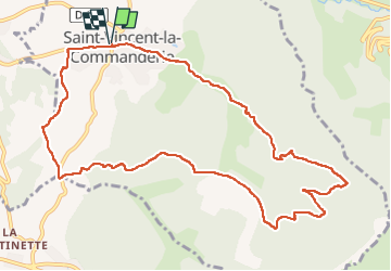

Longueur
12,3 km

Altitude max
746 m

Dénivelé positif
505 m
Km-Effort
19 km

Altitude min
328 m

Dénivelé négatif
505 m
Boucle
Oui
Date de création :
2024-02-01 08:24:22.625
Dernière modification :
2024-02-11 10:08:09.808
5h25
Difficulté : Très difficile

Application GPS de randonnée GRATUITE
 SityTrail
IGN / Instituts géographiques
SityTrail Plus
Le monde est à vous
À propos
Randonnée Marche de 12,3 km à découvrir à Auvergne-Rhône-Alpes, Drôme, Saint-Vincent-la-Commanderie. Cette randonnée est proposée par Monjean.
Localisation
Pays :
France
Région :
Auvergne-Rhône-Alpes
Département/Province :
Drôme
Commune :
Saint-Vincent-la-Commanderie
Localité :
Unknown
Départ:(Dec)
Départ:(UTM)
666961 ; 4978360 (31T) N.
Commentaires