


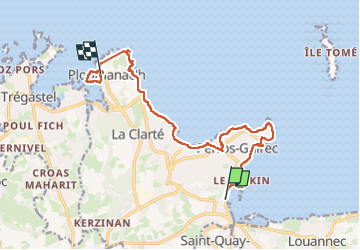
gr34 perros guirec - ploumanac'h

winkelmuller
Utilisateur

Longueur
13,5 km

Altitude max
59 m

Dénivelé positif
220 m
Km-Effort
16,4 km

Altitude min
-1 m

Dénivelé négatif
217 m
Boucle
Non
Date de création :
2024-03-13 07:46:54.749
Dernière modification :
2024-03-14 06:44:10.827
6h10
Difficulté : Difficile

Application GPS de randonnée GRATUITE
 SityTrail
IGN / Instituts géographiques
SityTrail Plus
Le monde est à vous
À propos
Randonnée Marche de 13,5 km à découvrir à Bretagne, Côtes-d'Armor, Perros-Guirec. Cette randonnée est proposée par winkelmuller.
Localisation
Pays :
France
Région :
Bretagne
Département/Province :
Côtes-d'Armor
Commune :
Perros-Guirec
Localité :
Unknown
Départ:(Dec)
Départ:(UTM)
467450 ; 5405697 (30U) N.
Commentaires