


Cani-Rando 2025

alfreson
Utilisateur

Longueur
74 km

Altitude max
495 m

Dénivelé positif
938 m
Km-Effort
87 km

Altitude min
224 m

Dénivelé négatif
1061 m
Boucle
Non
Date de création :
2025-01-05 09:22:30.0
Dernière modification :
2025-01-05 12:55:40.186
3h32
Difficulté : Très difficile

Application GPS de randonnée GRATUITE
 SityTrail
IGN / Instituts géographiques
SityTrail Plus
Le monde est à vous
À propos
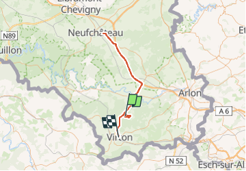
Randonnée Marche de 74 km à découvrir à Wallonie, Luxembourg, Virton. Cette randonnée est proposée par alfreson.
Description
À corriger, contient le trajet en voiture
Localisation
Pays :
Belgique
Région :
Wallonie
Département/Province :
Luxembourg
Commune :
Virton
Localité :
Ethe
Départ:(Dec)
Départ:(UTM)
684552 ; 5499892 (31U) N.
Commentaires