


Autour de Saint Antoine l'Abbaye - 26 janv 2025

morganee
Utilisateur
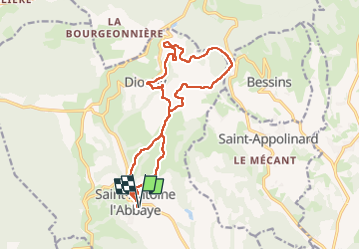

Longueur
17,1 km

Altitude max
635 m

Dénivelé positif
426 m
Km-Effort
23 km

Altitude min
349 m

Dénivelé négatif
427 m
Boucle
Oui
Date de création :
2025-01-26 10:13:25.078
Dernière modification :
2025-01-26 15:17:41.836
5h03
Difficulté : Facile

Application GPS de randonnée GRATUITE
 SityTrail
IGN / Instituts géographiques
SityTrail Plus
Le monde est à vous
À propos
Randonnée Marche de 17,1 km à découvrir à Auvergne-Rhône-Alpes, Isère, Saint-Antoine l'Abbaye. Cette randonnée est proposée par morganee.
Localisation
Pays :
France
Région :
Auvergne-Rhône-Alpes
Département/Province :
Isère
Commune :
Saint-Antoine l'Abbaye
Localité :
Saint-Antoine-l'Abbaye
Départ:(Dec)
Départ:(UTM)
674316 ; 5004564 (31T) N.
Commentaires