Randonnée Marche Villefranche-sur-Mer - Villas de Beaulieu 1 - Photo
 jlrayon
jlrayon

Utilisateur

© OpenStreetMap contributors
Longueur
Longueur
10,1 km
Altitude max
Altitude max
55 m
Dénivelé positif
Dénivelé positif
192 m
Km-Effort
Km-Effort  
12,7 km
Altitude min
Altitude min
-1 m
Dénivelé négatif
Dénivelé négatif
206 m
Boucle
Boucle
Non
Date de création :
2015-06-17 00:00:00.0
Dernière modification :
2015-06-17 00:00:00.0

(0 Avis)

Marche
Marche
2h08
Difficulté : Facile

Scannez ce code QR pour ouvrir la randonnée dans l'application SityTrail

Application GPS de randonnée GRATUITE

Logo SityTrail SityTrail

IGN / Instituts géographiques

Télécharger SityTrail sur l'App Store Télécharger SityTrail sur Google Play

Logo SityTrail SityTrail World

Le monde est à vous

Télécharger SityTrail sur l'App Store Télécharger SityTrail sur Google Play Télécharger SityTrail sur Huawei AppGallery

À propos

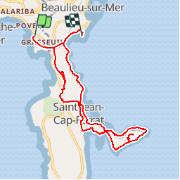
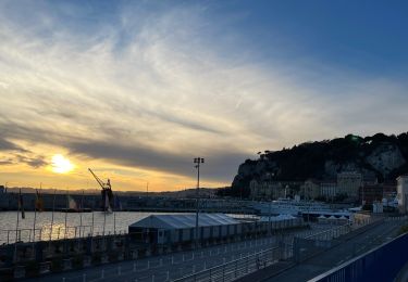
Randonnée Marche de 10,1 km à découvrir à Provence-Alpes-Côte d'Azur, Alpes-Maritimes, Villefranche-sur-Mer. Cette randonnée est proposée par jlrayon.

Description

Circuit Long
Départ : Parking de l’ange gardien -Port de St Jean Cap Ferrat –
Chapelle de Saint-Hospice - Plage de passable (Baignade et piquenique)
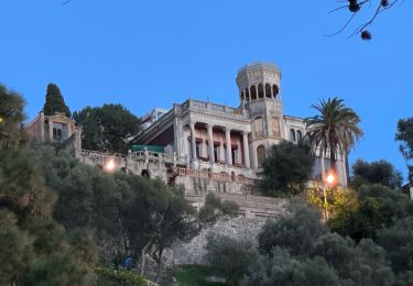
Villa Ephrussi de Rothschild -Villa Grecque Kérylos -Retour au parking

Profil altimétrique

Points d'intérêt

Point d'intérêt Saint-Jean-Cap-Ferrat - Saint-Hospice - Photo
jlrayon
SAINT-JEAN-CAP-FERRAT 
Point d'intérêt Saint-Jean-Cap-Ferrat - Plage de Passable - Photo
jlrayon
SAINT-JEAN-CAP-FERRAT 
Point d'intérêt Saint-Jean-Cap-Ferrat - Villa Ephrussi de Rothschild - Photo
jlrayon
SAINT-JEAN-CAP-FERRAT 
Point d'intérêt Beaulieu-sur-Mer - Villa Kerylos - Photo
jlrayon
BEAULIEU-SUR-MER 

Localisation

Pays :
France
Région :
Provence-Alpes-Côte d'Azur
Département/Province :
Alpes-Maritimes
Commune :
Villefranche-sur-Mer
Localité :
Unknown
Départ:(Dec)
Départ:(UTM)
364802 ; 4840302 (32T) N.

Randonnées à proximité

Randonnée Marche Nice - Ballade chemin des douaniers Nice-Villefranche  - Photo
Marche
coriace

Marche

Très facile
(1)
Nice, Provence-Alpes-Côte d'Azur, Alpes-Maritimes, France
7,9 km | 10,3 km-effort
2h 13min
Non
Randonnée Marche Saint-Jean-Cap-Ferrat - Cap Ferrat 2011-10-27 - Photo
Marche
Cricounet84

Marche

Moyen
(2)
Saint-Jean-Cap-Ferrat, Provence-Alpes-Côte d'Azur, Alpes-Maritimes, France
10,9 km | 14 km-effort
4h 0min
Oui
Randonnée A pied Èze - Circuit du mont Bastide - Photo
A pied
PRO

A pied

Facile
Èze, Provence-Alpes-Côte d'Azur, Alpes-Maritimes, France
7 km | 14,7 km-effort
3h 20min
Oui
Randonnée Marche Èze - Mont Bastide, sentier de Nietzsche - Photo
Marche
PEBREJOSIANE

Marche

Facile
(1)
Èze, Provence-Alpes-Côte d'Azur, Alpes-Maritimes, France
7,2 km | 15,1 km-effort
3h 15min
Oui
Randonnée Marche Saint-Jean-Cap-Ferrat - w-frankrijk-tour-du-cap-ferrat - Photo
Marche
gpstracks

Marche

Très facile
(1)
Saint-Jean-Cap-Ferrat, Provence-Alpes-Côte d'Azur, Alpes-Maritimes, France
6,5 km | 8,6 km-effort
Inconnu
Non
Randonnée Marche Èze - eze 221213 - Photo
Marche
legios84

Marche

Moyen
(1)
Èze, Provence-Alpes-Côte d'Azur, Alpes-Maritimes, France
9,9 km | 14,7 km-effort
2h 4min
Oui
Randonnée Marche Saint-Jean-Cap-Ferrat - Tour du Cap Ferrat - Photo
Marche
tracegps

Marche

Moyen
(4)
Saint-Jean-Cap-Ferrat, Provence-Alpes-Côte d'Azur, Alpes-Maritimes, France
8,9 km | 11,2 km-effort
2h 0min
Oui
Randonnée Marche Nice - Nice - Tour du Mont Boron - Photo
Marche
LightStalker

Marche

Facile
Nice, Provence-Alpes-Côte d'Azur, Alpes-Maritimes, France
7,3 km | 10,5 km-effort
2h 48min
Oui
Randonnée Marche Nice - Balade Niçoise : Centre-Ville, Vieux-Nice, Le Port - Photo
Marche
LightStalker

Marche

Très facile
Nice, Provence-Alpes-Côte d'Azur, Alpes-Maritimes, France
5,4 km | 7,2 km-effort
2h 30min
Oui


Fermer
Mes abonnements