![](/images/other/stat-length.png)
![Randonnée Marche Tain-l'Hermitage - Hermitage et Pierre Aiguille - Photo](https://media.geolcdn.com/t/1900/400/ext.pjpeg?maxdim=2&url=https%3A%2F%2Fstatic1.geolcdn.com%2Fsiteimages%2Fupload%2Ffiles%2F1553511878bg_sport_marche.png)
Hermitage et Pierre Aiguille
Brusa
Utilisateur
![Longueur](/images/other/stat-length.png)
Longueur
9,6 km
![Altitude max](https://static1.geolcdn.com/siteimages/upload/files/1508320355ic_sort_altitude_max_24dp.png)
Altitude max
335 m
![Dénivelé positif](https://static1.geolcdn.com/siteimages/upload/files/1508320355ic_sort_den_pos_24dp.png)
Dénivelé positif
347 m
![Km-Effort](/images/other/stat-length.png)
Km-Effort
14,2 km
![Altitude min](https://static1.geolcdn.com/siteimages/upload/files/1508320355ic_sort_altitude_min_24dp.png)
Altitude min
118 m
![Dénivelé négatif](https://static1.geolcdn.com/siteimages/upload/files/1508320355ic_sort_den_neg_24dp.png)
Dénivelé négatif
347 m
![Boucle](https://static1.geolcdn.com/siteimages/upload/files/16400158638029165_repeat_loop_refresh_sync_direction_icon.png)
Boucle
Oui
Date de création :
2015-07-11 00:00:00.0
Dernière modification :
2015-07-11 00:00:00.0
![Marche](https://static1.geolcdn.com/sitytour/trail-icons/101.png)
3h04
Difficulté : Moyen
![Scannez ce code QR pour ouvrir la randonnée dans l'application SityTrail](https://capi.geolives.com/qq0zvz2zws4bq2lad0pu/sitytour/trails/443783/qr.png?size=200)
Application GPS de randonnée GRATUITE
À propos
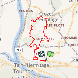
Randonnée Marche de 9,6 km à découvrir à Auvergne-Rhône-Alpes, Drôme, Tain-l'Hermitage. Cette randonnée est proposée par Brusa.
Description
Pour certains passages pentus et en gravillons, une paire de bâton est bienvenue.
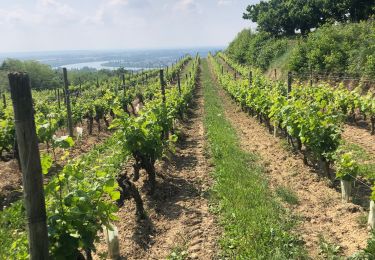
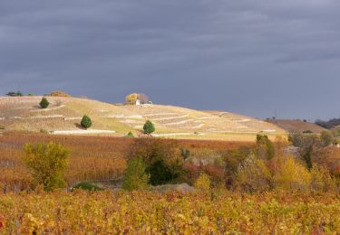
Dans la partie vigne on marche sur les pas de Gambert.
Localisation
Pays :
France
Région :
Auvergne-Rhône-Alpes
Département/Province :
Drôme
Commune :
Tain-l'Hermitage
Localité :
Unknown
Départ:(Dec)
Départ:(UTM)
645244 ; 4992703 (31T) N.
Commentaires
Randonnées à proximité
![Randonnée V.T.T. Tournon-sur-Rhône - Rando des tours 2009 - Photo](https://media.geolcdn.com/t/375/260/ext.jpg?maxdim=2&url=https%3A%2F%2Fstatic1.geolcdn.com%2Fsiteimages%2Fupload%2Ffiles%2F1524743154velo.jpg)
![V.T.T. V.T.T.](https://static1.geolcdn.com/sitytour/trail-icons/202.png)
Rando des tours 2009
V.T.T.
Difficile
(1)
Tournon-sur-Rhône,
Auvergne-Rhône-Alpes,
Ardèche,
France
![](/images/other/stat-length.png)
40 km | 53 km-effort
3h 23min
![](https://static1.geolcdn.com/siteimages/upload/files/16400158638029165_repeat_loop_refresh_sync_direction_icon.png)
Oui
![Randonnée Marche Tain-l'Hermitage - Tain l’Hermitage Croze - Photo](https://media.geolcdn.com/t/375/260/ext.jpg?maxdim=2&url=https%3A%2F%2Fmedia.geolcdn.com%2Ff%2Fefb46ab6-23ad-4c99-945e-829a690cf3f7.jpg)
![Marche Marche](https://static1.geolcdn.com/sitytour/trail-icons/101.png)
Tain l’Hermitage Croze
Marche
Moyen
Tain-l'Hermitage,
Auvergne-Rhône-Alpes,
Drôme,
France
![](/images/other/stat-length.png)
7,8 km | 12 km-effort
2h 5min
![](https://static1.geolcdn.com/siteimages/upload/files/16400158638029165_repeat_loop_refresh_sync_direction_icon.png)
Oui
![Randonnée V.T.T. Tournon-sur-Rhône - Tournon-Meyras par la route-retour Tournon 21km 520m - Photo](https://media.geolcdn.com/t/375/260/ext.jpg?maxdim=2&url=https%3A%2F%2Fstatic1.geolcdn.com%2Fsiteimages%2Fupload%2Ffiles%2F1524743154velo.jpg)
![V.T.T. V.T.T.](https://static1.geolcdn.com/sitytour/trail-icons/202.png)
Tournon-Meyras par la route-retour Tournon 21km 520m
V.T.T.
Moyen
(1)
Tournon-sur-Rhône,
Auvergne-Rhône-Alpes,
Ardèche,
France
![](/images/other/stat-length.png)
21 km | 28 km-effort
1h 54min
![](https://static1.geolcdn.com/siteimages/upload/files/16400158638029165_repeat_loop_refresh_sync_direction_icon.png)
Oui
![Randonnée Marche Tain-l'Hermitage - Gare Tain /Gite Bonnefontaine Plats par Mauves - Photo](https://media.geolcdn.com/t/375/260/ext.jpg?maxdim=2&url=https%3A%2F%2Fmedia.geolcdn.com%2Ff%2Fe869d95d-b57f-427e-ab66-384935494bbb.jpg)
![Marche Marche](https://static1.geolcdn.com/sitytour/trail-icons/101.png)
Gare Tain /Gite Bonnefontaine Plats par Mauves
Marche
Facile
Tain-l'Hermitage,
Auvergne-Rhône-Alpes,
Drôme,
France
![](/images/other/stat-length.png)
17,8 km | 24 km-effort
5h 23min
![](https://static1.geolcdn.com/siteimages/upload/files/16400158638029165_repeat_loop_refresh_sync_direction_icon.png)
Non
![Randonnée Marche Tain-l'Hermitage - Tain Gervans Crozes 14km - Photo](https://media.geolcdn.com/t/375/260/ext.jpg?maxdim=2&url=https%3A%2F%2Fmedia.geolcdn.com%2Ff%2F5eac1dd7-f084-4ef4-9659-9609ce6b6adf.jpg)
![Marche Marche](https://static1.geolcdn.com/sitytour/trail-icons/101.png)
Tain Gervans Crozes 14km
Marche
Très difficile
Tain-l'Hermitage,
Auvergne-Rhône-Alpes,
Drôme,
France
![](/images/other/stat-length.png)
14 km | 21 km-effort
4h 44min
![](https://static1.geolcdn.com/siteimages/upload/files/16400158638029165_repeat_loop_refresh_sync_direction_icon.png)
Oui
![Randonnée Marche Chantemerle-les-Blés - 26 Chantemerle les bles - Photo](https://media.geolcdn.com/t/375/260/ext.jpg?maxdim=2&url=https%3A%2F%2Fmedia.geolcdn.com%2Ff%2Fe7f73b94-acd8-4992-a63c-480111d0367d.jpg)
![Marche Marche](https://static1.geolcdn.com/sitytour/trail-icons/101.png)
26 Chantemerle les bles
Marche
Facile
Chantemerle-les-Blés,
Auvergne-Rhône-Alpes,
Drôme,
France
![](/images/other/stat-length.png)
11,8 km | 15 km-effort
2h 23min
![](https://static1.geolcdn.com/siteimages/upload/files/16400158638029165_repeat_loop_refresh_sync_direction_icon.png)
Oui
![Randonnée Marche Mauves - Mauves - Photo](https://media.geolcdn.com/t/375/260/ext.jpg?maxdim=2&url=https%3A%2F%2Fmedia.geolcdn.com%2Ff%2Fdbf45251-af59-465b-a7be-52b0efe48ad9.jpg)
![Marche Marche](https://static1.geolcdn.com/sitytour/trail-icons/101.png)
Mauves
Marche
Facile
Mauves,
Auvergne-Rhône-Alpes,
Ardèche,
France
![](/images/other/stat-length.png)
14,8 km | 22 km-effort
3h 51min
![](https://static1.geolcdn.com/siteimages/upload/files/16400158638029165_repeat_loop_refresh_sync_direction_icon.png)
Oui
![Randonnée Marche Chantemerle-les-Blés - chantemerles - Photo](https://media.geolcdn.com/t/375/260/ext.jpg?maxdim=2&url=https%3A%2F%2Fstatic1.geolcdn.com%2Fsiteimages%2Fupload%2Ffiles%2F1553511878bg_sport_marche.png)
![Marche Marche](https://static1.geolcdn.com/sitytour/trail-icons/101.png)
chantemerles
Marche
Facile
(2)
Chantemerle-les-Blés,
Auvergne-Rhône-Alpes,
Drôme,
France
![](/images/other/stat-length.png)
10 km | 12,5 km-effort
2h 6min
![](https://static1.geolcdn.com/siteimages/upload/files/16400158638029165_repeat_loop_refresh_sync_direction_icon.png)
Oui
![Randonnée Marche Tournon-sur-Rhône - F07300_Mauve_LT_AM_DS - Photo](https://media.geolcdn.com/t/375/260/ext.jpg?maxdim=2&url=https%3A%2F%2Fstatic1.geolcdn.com%2Fsiteimages%2Fupload%2Ffiles%2F1553511878bg_sport_marche.png)
![Marche Marche](https://static1.geolcdn.com/sitytour/trail-icons/101.png)
F07300_Mauve_LT_AM_DS
Marche
Facile
(1)
Tournon-sur-Rhône,
Auvergne-Rhône-Alpes,
Ardèche,
France
![](/images/other/stat-length.png)
11,2 km | 16,2 km-effort
4h 0min
![](https://static1.geolcdn.com/siteimages/upload/files/16400158638029165_repeat_loop_refresh_sync_direction_icon.png)
Oui