


Fourneau St-Michel 08/05/25

pierlan
Utilisateur
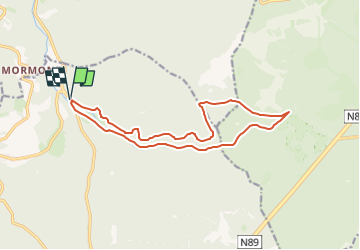

Longueur
13,9 km

Altitude max
545 m

Dénivelé positif
269 m
Km-Effort
17,5 km

Altitude min
299 m

Dénivelé négatif
266 m
Boucle
Oui
Date de création :
2025-05-05 07:19:58.003
Dernière modification :
2025-05-05 07:20:17.34
3h58
Difficulté : Facile

Application GPS de randonnée GRATUITE
 SityTrail
IGN / Instituts géographiques
SityTrail Plus
Le monde est à vous
À propos
Randonnée A pied de 13,9 km à découvrir à Wallonie, Luxembourg, Saint-Hubert. Cette randonnée est proposée par pierlan.
Localisation
Pays :
Belgique
Région :
Wallonie
Département/Province :
Luxembourg
Commune :
Saint-Hubert
Localité :
Unknown
Départ:(Dec)
Départ:(UTM)
667400 ; 5550666 (31U) N.
Commentaires