


Lay-Saint-Christophe:Les 2 étangs (11 kms)

noelphil
Utilisateur
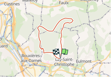

Longueur
11,4 km

Altitude max
362 m

Dénivelé positif
261 m
Km-Effort
14,9 km

Altitude min
207 m

Dénivelé négatif
259 m
Boucle
Oui
Date de création :
2025-06-23 05:43:10.605
Dernière modification :
2025-06-23 05:43:36.236
3h22
Difficulté : Difficile

Application GPS de randonnée GRATUITE
 SityTrail
IGN / Instituts géographiques
SityTrail Plus
Le monde est à vous
À propos
Randonnée Marche de 11,4 km à découvrir à Grand Est, Meurthe-et-Moselle, Lay-Saint-Christophe. Cette randonnée est proposée par noelphil.
Localisation
Pays :
France
Région :
Grand Est
Département/Province :
Meurthe-et-Moselle
Commune :
Lay-Saint-Christophe
Localité :
Unknown
Départ:(Dec)
Départ:(UTM)
293956 ; 5403549 (32U) N.
Commentaires