


Tellin VTT 32 Kms

B0uille
Utilisateur
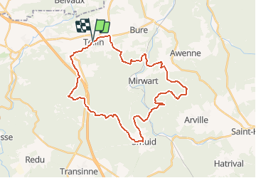

Longueur
32 km

Altitude max
488 m

Dénivelé positif
811 m
Km-Effort
43 km

Altitude min
243 m

Dénivelé négatif
813 m
Boucle
Oui
Date de création :
2015-08-16 00:00:00.0
Dernière modification :
2015-08-16 00:00:00.0
2h45
Difficulté : Moyen

Application GPS de randonnée GRATUITE
 SityTrail
IGN / Instituts géographiques
SityTrail Plus
Le monde est à vous
À propos
Randonnée V.T.T. de 32 km à découvrir à Wallonie, Luxembourg, Tellin. Cette randonnée est proposée par B0uille.


Localisation
Pays :
Belgique
Région :
Wallonie
Département/Province :
Luxembourg
Commune :
Tellin
Localité :
Tellin
Départ:(Dec)
Départ:(UTM)
658601 ; 5549945 (31U) N.
Commentaires