


Knocknacloghoge and Fancy Mtn

jaf299
Utilisateur
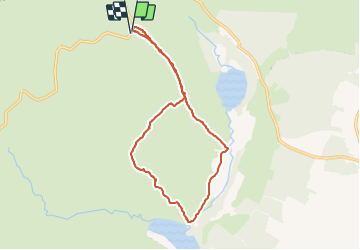

Longueur
13,1 km

Altitude max
590 m

Dénivelé positif
673 m
Km-Effort
22 km

Altitude min
208 m

Dénivelé négatif
672 m
Boucle
Oui
Date de création :
2014-12-10 00:00:00.0
Dernière modification :
2014-12-10 00:00:00.0
--
Difficulté : Inconnu

Application GPS de randonnée GRATUITE
 SityTrail
IGN / Instituts géographiques
SityTrail Plus
Le monde est à vous
À propos
Randonnée Marche de 13,1 km à découvrir à Inconnu, County Wicklow, The Municipal District of Wicklow. Cette randonnée est proposée par jaf299.
Localisation
Pays :
Irlande
Région :
Inconnu
Département/Province :
County Wicklow
Commune :
The Municipal District of Wicklow
Localité :
Glendalough
Départ:(Dec)
Départ:(UTM)
680568 ; 5888750 (29U) N.
Commentaires