


autrans(Le truc)-charande

maupassant38
Utilisateur
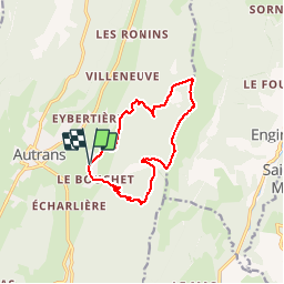

Longueur
11,9 km

Altitude max
1712 m

Dénivelé positif
661 m
Km-Effort
21 km

Altitude min
1097 m

Dénivelé négatif
662 m
Boucle
Oui
Date de création :
2019-02-22 22:31:15.24
Dernière modification :
2019-02-22 22:31:15.253
3h25
Difficulté : Moyen

Application GPS de randonnée GRATUITE
 SityTrail
IGN / Instituts géographiques
SityTrail Plus
Le monde est à vous
À propos
Randonnée Marche de 11,9 km à découvrir à Auvergne-Rhône-Alpes, Isère, Autrans-Méaudre en Vercors. Cette randonnée est proposée par maupassant38.
Localisation
Pays :
France
Région :
Auvergne-Rhône-Alpes
Département/Province :
Isère
Commune :
Autrans-Méaudre en Vercors
Localité :
Autrans
Départ:(Dec)
Départ:(UTM)
701172 ; 5005446 (31T) N.
Commentaires