


La Chal - Beauplat - Fau Cuchet

maupassant38
Utilisateur
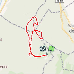

Longueur
7,4 km

Altitude max
1361 m

Dénivelé positif
302 m
Km-Effort
11,5 km

Altitude min
1134 m

Dénivelé négatif
302 m
Boucle
Oui
Date de création :
2019-02-22 22:31:13.157
Dernière modification :
2019-02-22 22:31:13.172
2h27
Difficulté : Facile

Application GPS de randonnée GRATUITE
 SityTrail
IGN / Instituts géographiques
SityTrail Plus
Le monde est à vous
À propos
Randonnée Marche de 7,4 km à découvrir à Auvergne-Rhône-Alpes, Isère, Saint-Georges-de-Commiers. Cette randonnée est proposée par maupassant38.
Localisation
Pays :
France
Région :
Auvergne-Rhône-Alpes
Département/Province :
Isère
Commune :
Saint-Georges-de-Commiers
Localité :
Unknown
Départ:(Dec)
Départ:(UTM)
716173 ; 4990979 (31T) N.
Commentaires