Randonnée V.T.T. Thiézac - descente du perthus - Photo
 Dominick
Dominick

Utilisateur

© OpenStreetMap contributors
Longueur
Longueur
308 km
Altitude max
Altitude max
1380 m
Dénivelé positif
Dénivelé positif
15194 m
Km-Effort
Km-Effort  
513 km
Altitude min
Altitude min
5 m
Dénivelé négatif
Dénivelé négatif
15916 m
Boucle
Boucle
Non
Date de création :
2016-08-07 00:00:00.0
Dernière modification :
2016-08-07 00:00:00.0

(0 Avis)

V.T.T.
V.T.T.
14h50
Difficulté : Moyen

Scannez ce code QR pour ouvrir la randonnée dans l'application SityTrail

Application GPS de randonnée GRATUITE

Logo SityTrail SityTrail

IGN / Instituts géographiques

Télécharger SityTrail sur l'App Store Télécharger SityTrail sur Google Play

Logo SityTrail SityTrail World

Le monde est à vous

Télécharger SityTrail sur l'App Store Télécharger SityTrail sur Google Play Télécharger SityTrail sur Huawei AppGallery

À propos

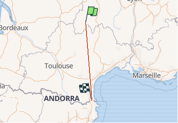
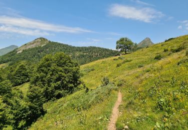
Randonnée V.T.T. de 308 km à découvrir à Auvergne-Rhône-Alpes, Cantal, Thiézac. Cette randonnée est proposée par Dominick.
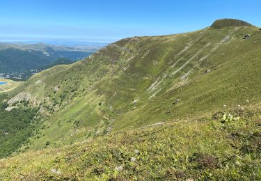
Description

Belle descente

Profil altimétrique

Localisation

Pays :
France
Région :
Auvergne-Rhône-Alpes
Département/Province :
Cantal
Commune :
Thiézac
Localité :
Unknown
Départ:(Dec)
Départ:(UTM)
473644 ; 4984672 (31T) N.

Randonnées à proximité

Randonnée Marche Thiézac - La Porte du Lion - Thiézac - Photo
Marche
tracegps

Marche

Moyen
(2)
Thiézac, Auvergne-Rhône-Alpes, Cantal, France
6,6 km | 10,5 km-effort
3h 0min
Oui
Randonnée Marche Pailherols - Pailherols  route de la montagne, plomb du Cantal - Photo
Marche
GUIDE
antignacs

Marche

Moyen
Pailherols, Auvergne-Rhône-Alpes, Cantal, France
22 km | 32 km-effort
7h 21min
Oui
Randonnée V.T.C. Mandailles-Saint-Julien - Tournemire  - Photo
V.T.C.
GUIDE
nadd73

V.T.C.

Moyen
Mandailles-Saint-Julien, Auvergne-Rhône-Alpes, Cantal, France
39 km | 50 km-effort
3h 2min
Non
Randonnée Marche Thiézac - Puy de la poche  - Photo
Marche
GUIDE
nadd73

Marche

Facile
Thiézac, Auvergne-Rhône-Alpes, Cantal, France
13,1 km | 23 km-effort
3h 14min
Oui
Randonnée Marche Thiézac - La porte du Lion - Thiézac - Photo
Marche
tracegps

Marche

Moyen
(2)
Thiézac, Auvergne-Rhône-Alpes, Cantal, France
7,6 km | 11,5 km-effort
3h 30min
Oui
Randonnée Trail Vic-sur-Cère - Cascade, la Garde, grotte des anglais  - Photo
Trail
GUIDE
nadd73

Trail

Facile
Vic-sur-Cère, Auvergne-Rhône-Alpes, Cantal, France
9,2 km | 16,7 km-effort
1h 49min
Oui
Randonnée Marche Vic-sur-Cère - Pas de Cère- cascade de Gourdole - Photo
Marche
crocau

Marche

Très facile
Vic-sur-Cère, Auvergne-Rhône-Alpes, Cantal, France
4,7 km | 6,6 km-effort
2h 0min
Oui
Randonnée Marche Thiézac - Les Gorges du Pas de Cère - Photo
Marche
VacheKiri67

Marche

Facile
Thiézac, Auvergne-Rhône-Alpes, Cantal, France
4,8 km | 6,8 km-effort
2h 21min
Oui
Randonnée Marche Saint-Jacques-des-Blats - Grange Dévézou col du Pertus par col du Gliziou - Photo
Marche
marionneau

Marche

Facile
Saint-Jacques-des-Blats, Auvergne-Rhône-Alpes, Cantal, France
16,8 km | 24 km-effort
4h 6min
Oui


Fermer
Mes abonnements