Randonnée Marche Tautavel - Tautavel - Tour Del Far - Photo
 ThonyM
ThonyM

Utilisateur

© OpenStreetMap contributors
Longueur
Longueur
71 km
Altitude max
Altitude max
481 m
Dénivelé positif
Dénivelé positif
1485 m
Km-Effort
Km-Effort  
90 km
Altitude min
Altitude min
51 m
Dénivelé négatif
Dénivelé négatif
1254 m
Boucle
Boucle
Non
Date de création :
2016-12-08 00:00:00.0
Dernière modification :
2016-12-08 00:00:00.0

(0 Avis)

Marche
Marche
5h53
Difficulté : Moyen

Scannez ce code QR pour ouvrir la randonnée dans l'application SityTrail

Application GPS de randonnée GRATUITE

Logo SityTrail SityTrail

IGN / Instituts géographiques

Télécharger SityTrail sur l'App Store Télécharger SityTrail sur Google Play

Logo SityTrail SityTrail World

Le monde est à vous

Télécharger SityTrail sur l'App Store Télécharger SityTrail sur Google Play Télécharger SityTrail sur Huawei AppGallery

À propos

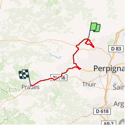
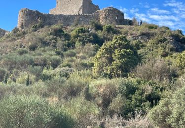
Randonnée Marche de 71 km à découvrir à Occitanie, Pyrénées-Orientales, Tautavel. Cette randonnée est proposée par ThonyM.

Description

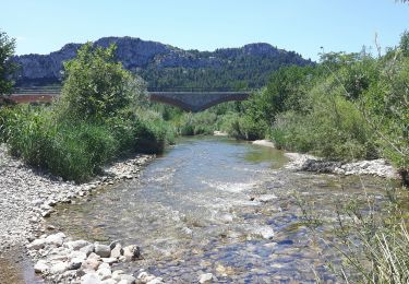
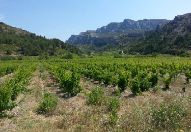
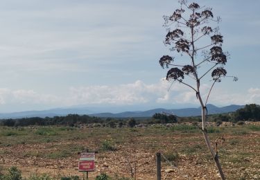
Une randonnée DNS le brouillard mais quand même agréable. Pas de difficulté majeure. Attention Xu pierres et racines glissantes par temps de pluie ou de brouillard

Profil altimétrique

Localisation

Pays :
France
Région :
Occitanie
Département/Province :
Pyrénées-Orientales
Commune :
Tautavel
Localité :
Unknown
Départ:(Dec)
Départ:(UTM)
479649 ; 4740655 (31T) N.

Randonnées à proximité

Randonnée Marche Tautavel - Tautavel chemin des bacs - Photo
Marche
jcmartin

Marche

Facile
(3)
Tautavel, Occitanie, Pyrénées-Orientales, France
9,5 km | 12,4 km-effort
2h 30min
Oui
Randonnée Marche Vingrau - Chemin des Contrebandiers Vingrau variante - Photo
Marche
force

Marche

Moyen
(2)
Vingrau, Occitanie, Pyrénées-Orientales, France
10,4 km | 16 km-effort
3h 30min
Oui
Randonnée Marche Vingrau - Vingrau - Photo
Marche
GUIDE
Ada11

Marche

Moyen
Vingrau, Occitanie, Pyrénées-Orientales, France
15,5 km | 22 km-effort
4h 20min
Oui
Randonnée Marche Estagel - ESTAGEL Chapelle St Laurent MARDI FAIT - Photo
Marche
MarcOBRECHT

Marche

Moyen
Estagel, Occitanie, Pyrénées-Orientales, France
12,2 km | 16,9 km-effort
3h 26min
Oui
Randonnée Marche Cases-de-Pène - 2023-08-01_12h04m36_SityTrail - 3754591 - Cases-de-Pene-x-detour-et-retour - Photo
Marche
ehalle8544

Marche

Moyen
Cases-de-Pène, Occitanie, Pyrénées-Orientales, France
5 km | 6,1 km-effort
1h 23min
Oui
Randonnée Marche Tautavel - les gorges . tautavel par les vignes  ..  retour par la vallée - Photo
Marche
GUIDE
stef789

Marche

Facile
Tautavel, Occitanie, Pyrénées-Orientales, France
8,2 km | 11 km-effort
2h 57min
Non
Randonnée Marche Paziols - paziols 19 kms - Photo
Marche
cappelle

Marche

Moyen
Paziols, Occitanie, Aude, France
18,6 km | 26 km-effort
6h 0min
Oui
Randonnée Marche Paziols - Paziols château d’aguilra - Photo
Marche
ombrabella

Marche

Très facile
Paziols, Occitanie, Aude, France
15,1 km | 18,8 km-effort
4h 4min
Oui
Randonnée Marche Tautavel - TAUTAVEL la Tour del Far A/R - Photo
Marche
MarieFrancoise

Marche

Moyen
Tautavel, Occitanie, Pyrénées-Orientales, France
6,3 km | 11,4 km-effort
3h 55min
Oui


Fermer
Mes abonnements