ryes 8 kms 2017

aubinjoel
Utilisateur
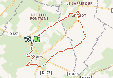

Longueur
7,8 km

Altitude max
57 m

Dénivelé positif
66 m
Km-Effort
8,7 km

Altitude min
11 m

Dénivelé négatif
70 m
Boucle
Oui
Date de création :
2017-07-10 00:00:00.0
Dernière modification :
2017-07-10 00:00:00.0
--
Difficulté : Facile

Application GPS de randonnée GRATUITE
 SityTrail
IGN / Instituts géographiques
SityTrail Plus
Le monde est à vous
À propos
Randonnée Marche de 7,8 km à découvrir à Normandie, Calvados, Ryes. Cette randonnée est proposée par aubinjoel.


Localisation
Pays :
France
Région :
Normandie
Département/Province :
Calvados
Commune :
Ryes
Localité :
Unknown
Départ:(Dec)
Départ:(UTM)
672335 ; 5465256 (30U) N.
Commentaires