


creully 12 kms 2017

aubinjoel
Utilisateur
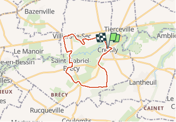

Longueur
11,4 km

Altitude max
54 m

Dénivelé positif
110 m
Km-Effort
12,8 km

Altitude min
8 m

Dénivelé négatif
112 m
Boucle
Oui
Date de création :
2017-08-07 00:00:00.0
Dernière modification :
2017-08-07 00:00:00.0
--
Difficulté : Facile

Application GPS de randonnée GRATUITE
 SityTrail
IGN / Instituts géographiques
SityTrail Plus
Le monde est à vous
À propos
Randonnée Marche de 11,4 km à découvrir à Normandie, Calvados, Creully sur Seulles. Cette randonnée est proposée par aubinjoel.


Localisation
Pays :
France
Région :
Normandie
Département/Province :
Calvados
Commune :
Creully sur Seulles
Localité :
Creully
Départ:(Dec)
Départ:(UTM)
678937 ; 5462076 (30U) N.
Commentaires
bien