


La Sambuy

florianlive
Utilisateur
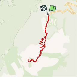

Longueur
7,5 km

Altitude max
2072 m

Dénivelé positif
912 m
Km-Effort
19,7 km

Altitude min
1151 m

Dénivelé négatif
916 m
Boucle
Oui
Date de création :
2017-09-03 00:00:00.0
Dernière modification :
2017-09-03 00:00:00.0
2h30
Difficulté : Inconnu

Application GPS de randonnée GRATUITE
 SityTrail
IGN / Instituts géographiques
SityTrail Plus
Le monde est à vous
À propos
Randonnée Autre activité de 7,5 km à découvrir à Auvergne-Rhône-Alpes, Haute-Savoie, Faverges-Seythenex. Cette randonnée est proposée par florianlive.
Localisation
Pays :
France
Région :
Auvergne-Rhône-Alpes
Département/Province :
Haute-Savoie
Commune :
Faverges-Seythenex
Localité :
Seythenex
Départ:(Dec)
Départ:(UTM)
287968 ; 5065784 (32T) N.
Commentaires