


Col de La Croix Perrin - Plénouze - La Molière

maupassant38
Utilisateur
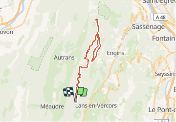

Longueur
35 km

Altitude max
1715 m

Dénivelé positif
883 m
Km-Effort
47 km

Altitude min
1224 m

Dénivelé négatif
882 m
Boucle
Oui
Date de création :
2019-02-22 22:30:49.306
Dernière modification :
2019-02-22 22:30:49.321
3h01
Difficulté : Moyen

Application GPS de randonnée GRATUITE
 SityTrail
IGN / Instituts géographiques
SityTrail Plus
Le monde est à vous
À propos
Randonnée V.T.T. de 35 km à découvrir à Auvergne-Rhône-Alpes, Isère, Lans-en-Vercors. Cette randonnée est proposée par maupassant38.
Localisation
Pays :
France
Région :
Auvergne-Rhône-Alpes
Département/Province :
Isère
Commune :
Lans-en-Vercors
Localité :
Unknown
Départ:(Dec)
Départ:(UTM)
701301 ; 5000620 (31T) N.
Commentaires