![](/images/other/stat-length.png)
![Randonnée Marche Pressagny-l'Orgueilleux - Pressagny-l'Orgueilleux (CircuitCatenay modifié1)_16Km - Photo](https://media.geolcdn.com/t/1900/400/ext.pjpeg?maxdim=2&url=https%3A%2F%2Fstatic1.geolcdn.com%2Fsiteimages%2Fupload%2Ffiles%2F1553511878bg_sport_marche.png)
Pressagny-l'Orgueilleux (CircuitCatenay modifié1)_16Km
douneto
Utilisateur
![Longueur](/images/other/stat-length.png)
Longueur
15,7 km
![Altitude max](https://static1.geolcdn.com/siteimages/upload/files/1508320355ic_sort_altitude_max_24dp.png)
Altitude max
155 m
![Dénivelé positif](https://static1.geolcdn.com/siteimages/upload/files/1508320355ic_sort_den_pos_24dp.png)
Dénivelé positif
199 m
![Km-Effort](/images/other/stat-length.png)
Km-Effort
18,4 km
![Altitude min](https://static1.geolcdn.com/siteimages/upload/files/1508320355ic_sort_altitude_min_24dp.png)
Altitude min
11 m
![Dénivelé négatif](https://static1.geolcdn.com/siteimages/upload/files/1508320355ic_sort_den_neg_24dp.png)
Dénivelé négatif
200 m
![Boucle](https://static1.geolcdn.com/siteimages/upload/files/16400158638029165_repeat_loop_refresh_sync_direction_icon.png)
Boucle
Oui
Date de création :
2019-04-30 14:31:56.322
Dernière modification :
2019-04-30 14:31:56.356
![Marche](https://static1.geolcdn.com/sitytour/trail-icons/101.png)
3h59
Difficulté : Moyen
![Scannez ce code QR pour ouvrir la randonnée dans l'application SityTrail](https://capi.geolives.com/qq0zvz2zws4bq2lad0pu/sitytour/trails/917708/qr.png?size=200)
Application GPS de randonnée GRATUITE
À propos
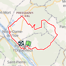
Randonnée Marche de 15,7 km à découvrir à Normandie, Eure, Pressagny-l'Orgueilleux. Cette randonnée est proposée par douneto.
Description
Rando Janvier 2016
Attention période chasse dans Bois du château goujon le lundi, Jeudi et Dimanche !!!(une partie du chemin balisé est privé)
Localisation
Pays :
France
Région :
Normandie
Département/Province :
Eure
Commune :
Pressagny-l'Orgueilleux
Localité :
Unknown
Départ:(Dec)
Départ:(UTM)
386525 ; 5443275 (31U) N.
Commentaires
Randonnées à proximité
![Randonnée Marche Mézières-en-Vexin - Mézières-en-Vexin - François 1er - Photo](https://media.geolcdn.com/t/375/260/ext.jpg?maxdim=2&url=https%3A%2F%2Fstatic1.geolcdn.com%2Fsiteimages%2Fupload%2Ffiles%2F1553511878bg_sport_marche.png)
![Marche Marche](https://static1.geolcdn.com/sitytour/trail-icons/101.png)
Mézières-en-Vexin - François 1er
Marche
Facile
(1)
Mézières-en-Vexin,
Normandie,
Eure,
France
![](/images/other/stat-length.png)
11 km | 13,1 km-effort
2h 50min
![](https://static1.geolcdn.com/siteimages/upload/files/16400158638029165_repeat_loop_refresh_sync_direction_icon.png)
Oui
![Randonnée Marche La Chapelle-Longueville - Saint Just - Les coteaux de Seine - Photo](https://media.geolcdn.com/t/375/260/ext.jpg?maxdim=2&url=https%3A%2F%2Fstatic1.geolcdn.com%2Fsiteimages%2Fupload%2Ffiles%2F1553511878bg_sport_marche.png)
![Marche Marche](https://static1.geolcdn.com/sitytour/trail-icons/101.png)
Saint Just - Les coteaux de Seine
Marche
Facile
(4)
La Chapelle-Longueville,
Normandie,
Eure,
France
![](/images/other/stat-length.png)
10,5 km | 13,8 km-effort
2h 57min
![](https://static1.geolcdn.com/siteimages/upload/files/16400158638029165_repeat_loop_refresh_sync_direction_icon.png)
Oui
![Randonnée Marche Vernon - Les falaises de Seine de Vernon à Mantes la Jolie - Photo](https://media.geolcdn.com/t/375/260/ext.jpg?maxdim=2&url=https%3A%2F%2Fmedia.geolcdn.com%2Ff%2F5fb6d91d-220e-4b46-8986-f386f1d9411e.jpg)
![Marche Marche](https://static1.geolcdn.com/sitytour/trail-icons/101.png)
Les falaises de Seine de Vernon à Mantes la Jolie
Marche
Difficile
Vernon,
Normandie,
Eure,
France
![](/images/other/stat-length.png)
37 km | 47 km-effort
7h 38min
![](https://static1.geolcdn.com/siteimages/upload/files/16400158638029165_repeat_loop_refresh_sync_direction_icon.png)
Non
![Randonnée Marche Saint-Pierre-de-Bailleul - A la rencontre des lavoirs - Photo](https://media.geolcdn.com/t/375/260/ext.jpg?maxdim=2&url=https%3A%2F%2Fmedia.geolcdn.com%2Ff%2Fb40e3295-f250-42fc-a673-b0658115f2e1.jpg)
![Marche Marche](https://static1.geolcdn.com/sitytour/trail-icons/101.png)
A la rencontre des lavoirs
Marche
Moyen
Saint-Pierre-de-Bailleul,
Normandie,
Eure,
France
![](/images/other/stat-length.png)
9,9 km | 12,6 km-effort
2h 50min
![](https://static1.geolcdn.com/siteimages/upload/files/16400158638029165_repeat_loop_refresh_sync_direction_icon.png)
Oui
![Randonnée V.T.T. Vernon - Les prés de Vernonnet - Vernon - Photo](https://media.geolcdn.com/t/375/260/ext.jpg?maxdim=2&url=https%3A%2F%2Fservices.sitytrail.com%2FGeolivesWS%2FDownloadMedia.ashx%3FTrailID%3D112611%26Media%3D11135_5.jpg)
![V.T.T. V.T.T.](https://static1.geolcdn.com/sitytour/trail-icons/202.png)
Les prés de Vernonnet - Vernon
V.T.T.
Facile
Vernon,
Normandie,
Eure,
France
![](/images/other/stat-length.png)
3,3 km | 3,7 km-effort
19min
![](https://static1.geolcdn.com/siteimages/upload/files/16400158638029165_repeat_loop_refresh_sync_direction_icon.png)
Oui
![Randonnée Marche Vernon - Les prés de Vernonnet - Vernon - Photo](https://media.geolcdn.com/t/375/260/ext.jpg?maxdim=2&url=https%3A%2F%2Fservices.sitytrail.com%2FGeolivesWS%2FDownloadMedia.ashx%3FTrailID%3D112610%26Media%3D11135_5.jpg)
![Marche Marche](https://static1.geolcdn.com/sitytour/trail-icons/101.png)
Les prés de Vernonnet - Vernon
Marche
Facile
Vernon,
Normandie,
Eure,
France
![](/images/other/stat-length.png)
3,3 km | 3,7 km-effort
49min
![](https://static1.geolcdn.com/siteimages/upload/files/16400158638029165_repeat_loop_refresh_sync_direction_icon.png)
Oui
![Randonnée Marche Vernon - Entre musée et château - Vernon - Photo](https://media.geolcdn.com/t/375/260/ext.jpg?maxdim=2&url=https%3A%2F%2Fservices.sitytrail.com%2FGeolivesWS%2FDownloadMedia.ashx%3FTrailID%3D112597%26Media%3D11073_6.jpg)
![Marche Marche](https://static1.geolcdn.com/sitytour/trail-icons/101.png)
Entre musée et château - Vernon
Marche
Facile
Vernon,
Normandie,
Eure,
France
![](/images/other/stat-length.png)
7,7 km | 9,6 km-effort
2h 0min
![](https://static1.geolcdn.com/siteimages/upload/files/16400158638029165_repeat_loop_refresh_sync_direction_icon.png)
Oui
![Randonnée Marche Vernon - Randonnée entre Seine et Forêt - Vernon - Photo](https://media.geolcdn.com/t/375/260/ext.jpg?maxdim=2&url=https%3A%2F%2Fservices.sitytrail.com%2FGeolivesWS%2FDownloadMedia.ashx%3FTrailID%3D112578%26Media%3D10992_3.jpg)
![Marche Marche](https://static1.geolcdn.com/sitytour/trail-icons/101.png)
Randonnée entre Seine et Forêt - Vernon
Marche
Facile
Vernon,
Normandie,
Eure,
France
![](/images/other/stat-length.png)
7,7 km | 9,5 km-effort
2h 0min
![](https://static1.geolcdn.com/siteimages/upload/files/16400158638029165_repeat_loop_refresh_sync_direction_icon.png)
Oui
![Randonnée V.T.T. Vernon - Circuit de la Colline aux oiseaux - Vernon - Photo](https://media.geolcdn.com/t/375/260/ext.jpg?maxdim=2&url=https%3A%2F%2Fservices.sitytrail.com%2FGeolivesWS%2FDownloadMedia.ashx%3FTrailID%3D112577%26Media%3D10990_2.jpg)
![V.T.T. V.T.T.](https://static1.geolcdn.com/sitytour/trail-icons/202.png)
Circuit de la Colline aux oiseaux - Vernon
V.T.T.
Facile
Vernon,
Normandie,
Eure,
France
![](/images/other/stat-length.png)
5,9 km | 7,3 km-effort
30min
![](https://static1.geolcdn.com/siteimages/upload/files/16400158638029165_repeat_loop_refresh_sync_direction_icon.png)
Oui