


la garde adhemar

losjo
Utilisateur
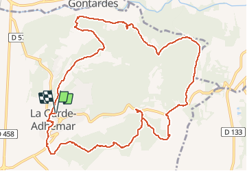

Longueur
14,4 km

Altitude max
233 m

Dénivelé positif
343 m
Km-Effort
19 km

Altitude min
81 m

Dénivelé négatif
342 m
Boucle
Oui
Date de création :
2018-04-17 22:29:12.328
Dernière modification :
2018-04-17 22:29:12.328
6h24
Difficulté : Facile

Application GPS de randonnée GRATUITE
 SityTrail
IGN / Instituts géographiques
SityTrail Plus
Le monde est à vous
À propos
Randonnée Marche de 14,4 km à découvrir à Auvergne-Rhône-Alpes, Drôme, La Garde-Adhémar. Cette randonnée est proposée par losjo.
Localisation
Pays :
France
Région :
Auvergne-Rhône-Alpes
Département/Province :
Drôme
Commune :
La Garde-Adhémar
Localité :
Unknown
Départ:(Dec)
Départ:(UTM)
639733 ; 4917159 (31T) N.
Commentaires