![](/images/other/stat-length.png)
![Randonnée Marche Évron - Balade autour d'Evron - Photo](https://media.geolcdn.com/t/1900/400/ext.pjpeg?maxdim=2&url=https%3A%2F%2Fstatic1.geolcdn.com%2Fsiteimages%2Fupload%2Ffiles%2F1553511878bg_sport_marche.png)
Balade autour d'Evron
Axelloceane
Utilisateur
![Longueur](/images/other/stat-length.png)
Longueur
12,7 km
![Altitude max](https://static1.geolcdn.com/siteimages/upload/files/1508320355ic_sort_altitude_max_24dp.png)
Altitude max
115 m
![Dénivelé positif](https://static1.geolcdn.com/siteimages/upload/files/1508320355ic_sort_den_pos_24dp.png)
Dénivelé positif
77 m
![Km-Effort](/images/other/stat-length.png)
Km-Effort
13,7 km
![Altitude min](https://static1.geolcdn.com/siteimages/upload/files/1508320355ic_sort_altitude_min_24dp.png)
Altitude min
94 m
![Dénivelé négatif](https://static1.geolcdn.com/siteimages/upload/files/1508320355ic_sort_den_neg_24dp.png)
Dénivelé négatif
75 m
![Boucle](https://static1.geolcdn.com/siteimages/upload/files/16400158638029165_repeat_loop_refresh_sync_direction_icon.png)
Boucle
Oui
Date de création :
2018-02-07 00:00:00.0
Dernière modification :
2018-02-07 00:00:00.0
![Marche](https://static1.geolcdn.com/sitytour/trail-icons/101.png)
3h02
Difficulté : Facile
![Scannez ce code QR pour ouvrir la randonnée dans l'application SityTrail](https://capi.geolives.com/qq0zvz2zws4bq2lad0pu/sitytour/trails/94276/qr.png?size=200)
Application GPS de randonnée GRATUITE
À propos
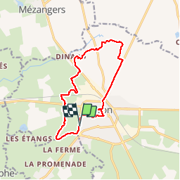
Randonnée Marche de 12,7 km à découvrir à Pays de la Loire, Mayenne, Évron. Cette randonnée est proposée par Axelloceane.
Description
départ du camping en suivant le circuit des marais ensuite prendre direction plan d''eau du gué De Selle.Au croisement sentier direction St Gemmes Le Robert retour par la route et une petite visite de la ville
Localisation
Pays :
France
Région :
Pays de la Loire
Département/Province :
Mayenne
Commune :
Évron
Localité :
Évron
Départ:(Dec)
Départ:(UTM)
692412 ; 5336294 (30U) N.
Commentaires
Randonnées à proximité
![Randonnée Marche Mézangers - PEDESTRES - circ 25 - la pierre l eau la foret le ... - Photo](https://media.geolcdn.com/t/375/260/ext.jpg?maxdim=2&url=https%3A%2F%2Fstatic1.geolcdn.com%2Fsiteimages%2Fupload%2Ffiles%2F1553511878bg_sport_marche.png)
![Marche Marche](https://static1.geolcdn.com/sitytour/trail-icons/101.png)
PEDESTRES - circ 25 - la pierre l eau la foret le ...
Marche
Moyen
Mézangers,
Pays de la Loire,
Mayenne,
France
![](/images/other/stat-length.png)
21 km | 23 km-effort
5h 13min
![](https://static1.geolcdn.com/siteimages/upload/files/16400158638029165_repeat_loop_refresh_sync_direction_icon.png)
Oui
![Randonnée Marche nordique Évron - Saint Christophe du Luat - Photo](https://media.geolcdn.com/t/375/260/ext.jpg?maxdim=2&url=https%3A%2F%2Fmedia.geolcdn.com%2Ff%2F54694222-3684-4f10-99c3-9d6afd113ca1.jpg)
![Marche nordique Marche nordique](https://static1.geolcdn.com/sitytour/trail-icons/102.png)
Saint Christophe du Luat
Marche nordique
Très facile
Évron,
Pays de la Loire,
Mayenne,
France
![](/images/other/stat-length.png)
12,5 km | 13,7 km-effort
2h 18min
![](https://static1.geolcdn.com/siteimages/upload/files/16400158638029165_repeat_loop_refresh_sync_direction_icon.png)
Oui
![Randonnée Marche Sainte-Gemmes-le-Robert - Ste Gemmes le Mont Rochard - Photo](https://media.geolcdn.com/t/375/260/ext.jpg?maxdim=2&url=https%3A%2F%2Fmedia.geolcdn.com%2Ff%2Fa1314ca7-1f24-4985-9f12-08a9e5b072a9.jpg)
![Marche Marche](https://static1.geolcdn.com/sitytour/trail-icons/101.png)
Ste Gemmes le Mont Rochard
Marche
Facile
Sainte-Gemmes-le-Robert,
Pays de la Loire,
Mayenne,
France
![](/images/other/stat-length.png)
12,2 km | 15,9 km-effort
2h 34min
![](https://static1.geolcdn.com/siteimages/upload/files/16400158638029165_repeat_loop_refresh_sync_direction_icon.png)
Oui
![Randonnée Cheval Mézangers - Maeva_Rando Cheval du 6 avril 2015 - Photo](https://media.geolcdn.com/t/375/260/ext.jpg?maxdim=2&url=https%3A%2F%2Fstatic1.geolcdn.com%2Fsiteimages%2Fupload%2Ffiles%2F1524743154cheval.jpg)
![Cheval Cheval](https://static1.geolcdn.com/sitytour/trail-icons/300.png)
Maeva_Rando Cheval du 6 avril 2015
Cheval
Facile
Mézangers,
Pays de la Loire,
Mayenne,
France
![](/images/other/stat-length.png)
17,6 km | 19,7 km-effort
2h 30min
![](https://static1.geolcdn.com/siteimages/upload/files/16400158638029165_repeat_loop_refresh_sync_direction_icon.png)
Oui
![Randonnée Cheval Mézangers - Tour de la Rebeurrière - Photo](https://media.geolcdn.com/t/375/260/ext.jpg?maxdim=2&url=https%3A%2F%2Fstatic1.geolcdn.com%2Fsiteimages%2Fupload%2Ffiles%2F1524743154cheval.jpg)
![Cheval Cheval](https://static1.geolcdn.com/sitytour/trail-icons/300.png)
Tour de la Rebeurrière
Cheval
Très facile
Mézangers,
Pays de la Loire,
Mayenne,
France
![](/images/other/stat-length.png)
19,4 km | 22 km-effort
3h 17min
![](https://static1.geolcdn.com/siteimages/upload/files/16400158638029165_repeat_loop_refresh_sync_direction_icon.png)
Oui
![Randonnée Marche Évron - Châtres la Forêt - Photo](https://media.geolcdn.com/t/375/260/ext.jpg?maxdim=2&url=https%3A%2F%2Fstatic1.geolcdn.com%2Fsiteimages%2Fupload%2Ffiles%2F1553511878bg_sport_marche.png)
![Marche Marche](https://static1.geolcdn.com/sitytour/trail-icons/101.png)
Châtres la Forêt
Marche
Moyen
Évron,
Pays de la Loire,
Mayenne,
France
![](/images/other/stat-length.png)
10 km | 11 km-effort
2h 49min
![](https://static1.geolcdn.com/siteimages/upload/files/16400158638029165_repeat_loop_refresh_sync_direction_icon.png)
Oui
![Randonnée Marche Mézangers - PEDESTRES - circ 21 - Etiveau - Photo](https://media.geolcdn.com/t/375/260/ext.jpg?maxdim=2&url=https%3A%2F%2Fstatic1.geolcdn.com%2Fsiteimages%2Fupload%2Ffiles%2F1553511878bg_sport_marche.png)
![Marche Marche](https://static1.geolcdn.com/sitytour/trail-icons/101.png)
PEDESTRES - circ 21 - Etiveau
Marche
Très difficile
(2)
Mézangers,
Pays de la Loire,
Mayenne,
France
![](/images/other/stat-length.png)
21 km | 23 km-effort
5h 13min
![](https://static1.geolcdn.com/siteimages/upload/files/16400158638029165_repeat_loop_refresh_sync_direction_icon.png)
Oui
![Randonnée Marche nordique Évron - st Christophe du Luat - Photo](https://media.geolcdn.com/t/375/260/ext.jpg?maxdim=2&url=https%3A%2F%2Fstatic1.geolcdn.com%2Fsiteimages%2Fupload%2Ffiles%2F1545311037marcheuse_200dpi.jpg)
![Marche nordique Marche nordique](https://static1.geolcdn.com/sitytour/trail-icons/102.png)
st Christophe du Luat
Marche nordique
Très facile
Évron,
Pays de la Loire,
Mayenne,
France
![](/images/other/stat-length.png)
14,1 km | 15,8 km-effort
2h 30min
![](https://static1.geolcdn.com/siteimages/upload/files/16400158638029165_repeat_loop_refresh_sync_direction_icon.png)
Oui
![Randonnée Marche Sainte-Gemmes-le-Robert - sainte gemmes le robert - Photo](https://media.geolcdn.com/t/375/260/ext.jpg?maxdim=2&url=https%3A%2F%2Fstatic1.geolcdn.com%2Fsiteimages%2Fupload%2Ffiles%2F1553511878bg_sport_marche.png)
![Marche Marche](https://static1.geolcdn.com/sitytour/trail-icons/101.png)
sainte gemmes le robert
Marche
Facile
Sainte-Gemmes-le-Robert,
Pays de la Loire,
Mayenne,
France
![](/images/other/stat-length.png)
12,4 km | 16,1 km-effort
3h 17min
![](https://static1.geolcdn.com/siteimages/upload/files/16400158638029165_repeat_loop_refresh_sync_direction_icon.png)
Oui