Trail Running Bart - Bart/Mont Bart/Le Sainans/Sainte Suzanne - Photo

Bart/Mont Bart/Le Sainans/Sainte Suzanne

© OpenStreetMap contributors
Length
Length
18.7 km
Max alt
Max alt
468 m
Uphill gradient
Uphill gradient
459 m
Km-Effort
Km-Effort  
25 km
Min alt
Min alt
308 m
Downhill gradient
Downhill gradient
457 m
Boucle
Boucle
Yes
Creation date :
2014-12-10 00:00:00.0
Updated on :
2014-12-10 00:00:00.0

(0 Reviews)

Running
Running
2h00
Difficulty : Medium

Scan this QR Code to open this trail in the SityTrail application

FREE GPS app for hiking

Logo SityTrail SityTrail

IGN / Geographical institutes

Download SityTrail from the App Store Download SityTrail from Google Play

Logo SityTrail SityTrail World

The world is yours!

Download SityTrail from the App Store Download SityTrail from Google Play Download SityTrail on Huawei AppGallery

About

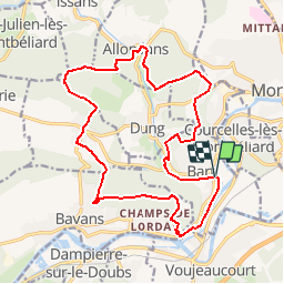
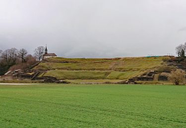
Trail Running of 18.7 km to be discovered at Bourgogne-Franche-Comté, Doubs, Bart. This trail is proposed by julien.millier.

Description

Départ de Bart , Montée au fort du mont Bart, descente sur presentvillers, direction allondans par le bois du sainans, retour sur Bart en passant par Sainte Suzanne

Elevation profile

Points of interest

Point of interest Bavans - Fort du Mont Bart - Photo
julien.millier
Point of interest Dung - Ferme du Sainans - Photo
julien.millier

Positioning

Country:
France
Region :
Bourgogne-Franche-Comté
Department/Province :
Doubs
Municipality :
Bart
Location:
Unknown
Start:(UTM)
332198 ; 5262229 (32T) N.

Trails nearby

Trail Walking Dung - dung - Photo
Walking
Evelyne3

Walking

Difficult
Dung, Bourgogne-Franche-Comté, Doubs, France
11.5 km | 15.8 km-effort
2h 24min
Yes
Trail Other activity Voujeaucourt - de voujeaucourt à Dambelin, puis pont de roide  - Photo
Other activity
jibus90

Other activity

Very easy
Voujeaucourt, Bourgogne-Franche-Comté, Doubs, France
57 km | 77 km-effort
4h 46min
Yes
Trail sport Montbéliard - Marche de Noël  - Photo
sport
klopbill

sport

Very easy
Montbéliard, Bourgogne-Franche-Comté, Doubs, France
9.1 km | 10.7 km-effort
Unknown
No
Trail Mountain bike Montbéliard - rando VTT club de montbeliard  - Photo
Mountain bike
francislassauce

Mountain bike

Very difficult
Montbéliard, Bourgogne-Franche-Comté, Doubs, France
44 km | 56 km-effort
3h 45min
Yes
Trail Walking Montbéliard - zz - Photo
Walking
Denis Roussel

Walking

Very difficult
Montbéliard, Bourgogne-Franche-Comté, Doubs, France
161 km | 203 km-effort
40h 22min
No
Trail Bicycle tourism Arbouans - GTJ #1 - Photo
Bicycle tourism
GUIDE
David25400

Bicycle tourism

Very difficult
Arbouans, Bourgogne-Franche-Comté, Doubs, France
108 km | 142 km-effort
10h 18min
No
Trail Walking Saint-Julien-lès-Montbéliard - St julien 160621 - Photo
Walking
GUIDE
David25400

Walking

Very easy
Saint-Julien-lès-Montbéliard, Bourgogne-Franche-Comté, Doubs, France
6.3 km | 8.2 km-effort
1h 54min
Yes
Trail Walking Mandeure - Mandeure 1 - Photo
Walking
randovoujo

Walking

Medium
Mandeure, Bourgogne-Franche-Comté, Doubs, France
9 km | 11.9 km-effort
2h 42min
Yes
Trail Walking Mandeure - Etape 1 GTJ : Mandeure à Pont de Roide - Photo
Walking
annefrance70

Walking

Easy
Mandeure, Bourgogne-Franche-Comté, Doubs, France
14 km | 18.1 km-effort
4h 40min
No


Close
My subscriptions