Trail Other activity Wiler bei Utzenstorf - Wo ist Tscheppach - Photo
© OpenStreetMap contributors
Length
Length
18.3 km
Max alt
Max alt
616 m
Uphill gradient
Uphill gradient
329 m
Km-Effort
Km-Effort  
23 km
Min alt
Min alt
458 m
Downhill gradient
Downhill gradient
330 m
Boucle
Boucle
Yes
Creation date :
2014-12-11 00:00:00.0
Updated on :
2014-12-11 00:00:00.0

(0 Reviews)

Other activity
Other activity
--
Difficulty : Unknown

Scan this QR Code to open this trail in the SityTrail application

FREE GPS app for hiking

Logo SityTrail SityTrail

IGN / Geographical institutes

Download SityTrail from the App Store Download SityTrail from Google Play

Logo SityTrail SityTrail World

The world is yours!

Download SityTrail from the App Store Download SityTrail from Google Play Download SityTrail on Huawei AppGallery

About

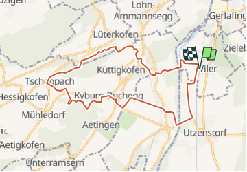
Trail Other activity of 18.3 km to be discovered at Bern, Emmental administrative district, Wiler bei Utzenstorf. This trail is proposed by bayardpaul.

Description

Wiler bei Utzenstorf
Bätterkinden
Mühledorf
Tscheppach
Nennigkofen
Lohn Ammannsegg

Elevation profile

Positioning

Country:
Switzerland
Region :
Bern
Department/Province :
Emmental administrative district
Municipality :
Wiler bei Utzenstorf
Location:
Unknown
Start:(UTM)
390473 ; 5222949 (32T) N.

Trails nearby

Trail On foot Lohn-Ammannsegg - Lohn Lüterkofen - Biberist - Photo
On foot
PRO

On foot

Easy
Lohn-Ammannsegg, Solothurn, Bezirk Wasseramt, Switzerland
3.8 km | 4.1 km-effort
56min
No


Close
My subscriptions