Trail Walking Champcueil - Saut du postillon Loutteville - Photo

Saut du postillon Loutteville

© OpenStreetMap contributors
Length
Length
14.7 km
Max alt
Max alt
147 m
Uphill gradient
Uphill gradient
241 m
Km-Effort
Km-Effort  
17.9 km
Min alt
Min alt
79 m
Downhill gradient
Downhill gradient
242 m
Boucle
Boucle
Yes
Creation date :
2017-01-09 00:00:00.0
Updated on :
2017-01-09 00:00:00.0

(0 Reviews)

Walking
Walking
3h53
Difficulty : Medium

Scan this QR Code to open this trail in the SityTrail application

FREE GPS app for hiking

Logo SityTrail SityTrail

IGN / Geographical institutes

Download SityTrail from the App Store Download SityTrail from Google Play

Logo SityTrail SityTrail World

The world is yours!

Download SityTrail from the App Store Download SityTrail from Google Play Download SityTrail on Huawei AppGallery

About

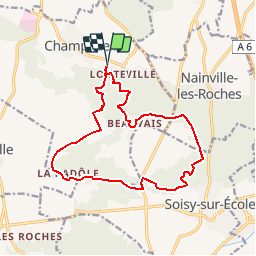
Trail Walking of 14.7 km to be discovered at Ile-de-France, Essonne, Champcueil. This trail is proposed by jctinchebray.

Description

Randonnée boucle de 15 km au départ de Loutteville et passant par la Padole, le saut du postillon et Beauvais.

Elevation profile

Positioning

Country:
France
Region :
Ile-de-France
Department/Province :
Essonne
Municipality :
Champcueil
Location:
Unknown
Start:(UTM)
460087 ; 5373157 (31U) N.

Trails nearby

Trail Walking Champcueil - JC 51 - 18,4 km - 320m - Champcueil, Les Grands Avaux - 23 km Effort - Photo
Walking

Walking

Difficult
(1)
Champcueil, Ile-de-France, Essonne, France
17.7 km | 22 km-effort
4h 58min
Yes
Trail On foot Champcueil - Balade entre Brie de Gâtinais - Photo
On foot
PRO

On foot

Easy
Champcueil, Ile-de-France, Essonne, France
13.1 km | 15.7 km-effort
3h 33min
No
Trail Nordic walking Mennecy - mennecy  vs mennecy - Photo
Nordic walking
gwenleterrible

Nordic walking

Very easy
(1)
Mennecy, Ile-de-France, Essonne, France
6.8 km | 7.6 km-effort
1h 40min
Yes
Trail Walking Mennecy - Mennecy - Photo
Walking
IreneProvost

Walking

Easy
(1)
Mennecy, Ile-de-France, Essonne, France
14.1 km | 16 km-effort
3h 30min
Yes
Trail Walking Champcueil - Grands Avaux - Tertre blanc  (Nainville) - fait - Photo
Walking
nicolas93

Walking

Easy
(1)
Champcueil, Ile-de-France, Essonne, France
17.7 km | 22 km-effort
4h 51min
Yes
Trail Walking Mondeville - Boucle mondeville par videlles - Photo
Walking
Glurps

Walking

Very easy
(1)
Mondeville, Ile-de-France, Essonne, France
16.1 km | 18.6 km-effort
4h 2min
Yes
Trail Walking Saint-Germain-sur-École - Boucle soisy version definitif - Photo
Walking
chessyca

Walking

Easy
Saint-Germain-sur-École, Ile-de-France, Seine-et-Marne, France
22 km | 26 km-effort
4h 53min
Yes
Trail On foot Saint-Germain-sur-École - Boucle Soisy Sur Ecole - Photo
On foot
chessyca

On foot

Medium
(1)
Saint-Germain-sur-École, Ile-de-France, Seine-et-Marne, France
21 km | 25 km-effort
5h 39min
Yes
Trail Walking Champcueil - Champcueil - Photo
Walking
guydu41

Walking

Medium
Champcueil, Ile-de-France, Essonne, France
8.2 km | 10.2 km-effort
2h 19min
Yes


Close
My subscriptions