Trail Cycle Pont-Sainte-Maxence - AU5V pont circuit 2 - Photo
© OpenStreetMap contributors
Length
Length
19.8 km
Max alt
Max alt
150 m
Uphill gradient
Uphill gradient
222 m
Km-Effort
Km-Effort  
23 km
Min alt
Min alt
85 m
Downhill gradient
Downhill gradient
222 m
Boucle
Boucle
Yes
Creation date :
2017-04-04 00:00:00.0
Updated on :
2017-04-04 00:00:00.0

(0 Reviews)

Cycle
Cycle
2h00
Difficulty : Medium

Scan this QR Code to open this trail in the SityTrail application

FREE GPS app for hiking

Logo SityTrail SityTrail

IGN / Geographical institutes

Download SityTrail from the App Store Download SityTrail from Google Play

Logo SityTrail SityTrail World

The world is yours!

Download SityTrail from the App Store Download SityTrail from Google Play Download SityTrail on Huawei AppGallery

About

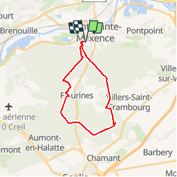
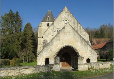
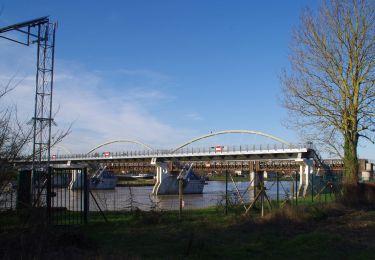
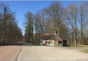
Trail Cycle of 19.8 km to be discovered at Hauts-de-France, Oise, Pont-Sainte-Maxence. This trail is proposed by gilbertdu60.

Description

balade en halatte, vers les ruines gallo romaine de Chamant, retour par Fleurines

Elevation profile

Points of interest

Point of interest Pont-Sainte-Maxence - traversée RD1017 - Photo
gilbertdu60
PONT-SAINTE-MAXENCE 
Point of interest Pont-Sainte-Maxence - Poteau du grand maitre - Photo
gilbertdu60
PONT-SAINTE-MAXENCE 
Point of interest Villers-Saint-Frambourg-Ognon - ruines gallo Romaine Chamant - Photo
gilbertdu60
VILLERS-SAINT-FRAMBOURG-OGNON 
Point of interest Senlis - Traversée RD1017 II - Photo
gilbertdu60
Point of interest Senlis - pavillon chasse - Photo
gilbertdu60
Point of interest Fleurines -  D565 - Photo
gilbertdu60
FLEURINES 
Point of interest Fleurines - station  - Photo
gilbertdu60
FLEURINES 

Positioning

Country:
France
Region :
Hauts-de-France
Department/Province :
Oise
Municipality :
Pont-Sainte-Maxence
Location:
Unknown
Start:(UTM)
470619 ; 5460234 (31U) N.

Trails nearby

Trail Walking Beaurepaire - La mare aux oiseaux - Beaurepaire - Photo
Walking
tracegps

Walking

Medium
(1)
Beaurepaire, Hauts-de-France, Oise, France
8.4 km | 10.2 km-effort
2h 10min
Yes
Trail Walking Fleurines - Fleurines Grand parcours - Photo
Walking
CC.RIDER

Walking

Easy
(1)
Fleurines, Hauts-de-France, Oise, France
20 km | 24 km-effort
5h 8min
Yes
Trail Walking Pontpoint - Mont Pagnotte Grand parcours - Photo
Walking
CC.RIDER

Walking

Medium
(2)
Pontpoint, Hauts-de-France, Oise, France
16.6 km | 22 km-effort
4h 36min
Yes
Trail Hybrid bike Fleurines - randonnée Au5v OT Ccpoh halatte - Photo
Hybrid bike
gilbertdu60

Hybrid bike

Easy
Fleurines, Hauts-de-France, Oise, France
30 km | 35 km-effort
Unknown
Yes
Trail Bicycle tourism Pont-Sainte-Maxence - sortie AU5v Pentecôte 2022 - Photo
Bicycle tourism
gilbertdu60

Bicycle tourism

Easy
Pont-Sainte-Maxence, Hauts-de-France, Oise, France
26 km | 29 km-effort
Unknown
Yes
Trail On foot Pont-Sainte-Maxence - balade pedestre 11 avril 2022 - Photo
On foot
gilbertdu60

On foot

Easy
Pont-Sainte-Maxence, Hauts-de-France, Oise, France
7.2 km | 9.1 km-effort
2h 4min
Yes
Trail Electric bike Pont-Sainte-Maxence - balade printanière du 23 mars - Photo
Electric bike
gilbertdu60

Electric bike

Easy
Pont-Sainte-Maxence, Hauts-de-France, Oise, France
22 km | 26 km-effort
2h 14min
Yes
Trail Electric bike Pont-Sainte-Maxence - sortie 18 janvier 22 - Photo
Electric bike
gilbertdu60

Electric bike

Easy
Pont-Sainte-Maxence, Hauts-de-France, Oise, France
23 km | 27 km-effort
2h 4min
Yes
Trail Electric bike Pont-Sainte-Maxence - balade décembre 1er jour hiver - Photo
Electric bike
gilbertdu60

Electric bike

Easy
Pont-Sainte-Maxence, Hauts-de-France, Oise, France
27 km | 32 km-effort
2h 21min
Yes


Close
My subscriptions