Randonnée Marche Braine-l'Alleud - BLA 0117 - Photo
 calofrancis
calofrancis

Utilisateur

© OpenStreetMap contributors
Longueur
Longueur
7,3 km
Altitude max
Altitude max
116 m
Dénivelé positif
Dénivelé positif
86 m
Km-Effort
Km-Effort  
8,4 km
Altitude min
Altitude min
74 m
Dénivelé négatif
Dénivelé négatif
86 m
Boucle
Boucle
Oui
Date de création :
2018-07-07 13:32:56.256
Dernière modification :
2018-07-07 13:32:56.256

(0 Avis)

Marche
Marche
1h52
Difficulté : Facile

Scannez ce code QR pour ouvrir la randonnée dans l'application SityTrail

Application GPS de randonnée GRATUITE

Logo SityTrail SityTrail

IGN / Instituts géographiques

Télécharger SityTrail sur l'App Store Télécharger SityTrail sur Google Play

Logo SityTrail SityTrail World

Le monde est à vous

Télécharger SityTrail sur l'App Store Télécharger SityTrail sur Google Play Télécharger SityTrail sur Huawei AppGallery

À propos

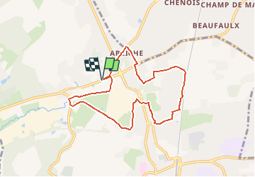
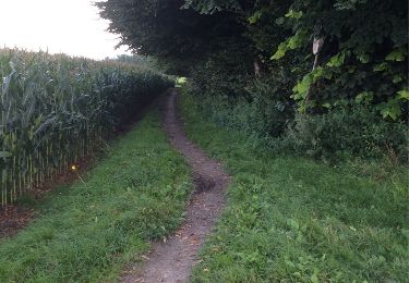
Randonnée Marche de 7,3 km à découvrir à Wallonie, Brabant wallon, Braine-l'Alleud. Cette randonnée est proposée par calofrancis.

Description

Ancienne "balade au bord de l'eau" qui n'est plus reprise sur le site de BLA ...
Parcours urbain et semi urbain
___www.marcheursdumardi.be___

Profil altimétrique

Localisation

Pays :
Belgique
Région :
Wallonie
Département/Province :
Brabant wallon
Commune :
Braine-l'Alleud
Localité :
Braine-l'Alleud
Départ:(Dec)
Départ:(UTM)
595894 ; 5617161 (31U) N.

Randonnées à proximité

Randonnée Marche Braine-l'Alleud - RB-Bw-13_Braine-l'Alleud - Photo
Marche
PRO

Marche

Très difficile
(5)
Braine-l'Alleud, Wallonie, Brabant wallon, Belgique
21 km | 27 km-effort
6h 2min
Oui
Randonnée Marche Braine-l'Alleud - RB-Bw-13_Braine-l'Alleud_via-racc-1-et-var - Photo
Marche
PRO

Marche

Difficile
(6)
Braine-l'Alleud, Wallonie, Brabant wallon, Belgique
14,8 km | 18,8 km-effort
4h 16min
Oui
Randonnée V.T.T. Braine-l'Alleud - O2bikers_58_Waterloo - Photo
V.T.T.
GUIDE+

V.T.T.

Très facile
(5)
Braine-l'Alleud, Wallonie, Brabant wallon, Belgique
30 km | 37 km-effort
4h 11min
Oui
Randonnée V.T.T. Waterloo - De Waterloo à la forêt de Soignes - Photo
V.T.T.
GUIDE
pascalou73

V.T.T.

Moyen
(1)
Waterloo, Wallonie, Brabant wallon, Belgique
39 km | 47 km-effort
3h 1min
Oui
Randonnée V.T.T. Rhode-Saint-Genèse - VTT des etangs - Photo
V.T.T.
GUIDE
pascalou73

V.T.T.

Moyen
(1)
Rhode-Saint-Genèse, Flandre, Brabant flamand, Belgique
31 km | 37 km-effort
2h 24min
Non
Randonnée Marche Braine-l'Alleud - #221003 - Braine-l'Alleud, Timpe et Tard et Bois du Foriest, Parc et Lac du Paradis**** - Photo
Marche
Randos Ouvertes

Marche

Moyen
(1)
Braine-l'Alleud, Wallonie, Brabant wallon, Belgique
8,1 km | 9,8 km-effort
2h 13min
Oui
Randonnée Vélo Waterloo - Du Domaine Solvay (Château de La Hulpe + Fondation Folon) à la Butte du Lion - Photo
Vélo
Waterloo Tourisme

Vélo

Très facile
(2)
Waterloo, Wallonie, Brabant wallon, Belgique
28 km | 32 km-effort
Inconnu
Non
Randonnée Marche Braine-l'Alleud - Promenade 1815 - Photo
Marche
Waterloo Tourisme

Marche

Difficile
(3)
Braine-l'Alleud, Wallonie, Brabant wallon, Belgique
14,4 km | 16,7 km-effort
3h 39min
Oui
Randonnée Marche Braine-l'Alleud - Entre l'Ermite et Odeghien - Photo
Marche
samlrando

Marche

Facile
(3)
Braine-l'Alleud, Wallonie, Brabant wallon, Belgique
7,2 km | 8,7 km-effort
1h 52min
Non


Fermer
Mes abonnements