


vtt rots thaon 22 kms

aubinjoel
Gebruiker
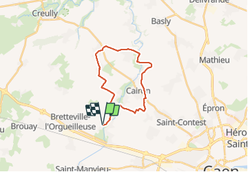

Lengte
21 km

Max. hoogte
63 m

Positief hoogteverschil
166 m
Km-Effort
24 km

Min. hoogte
23 m

Negatief hoogteverschil
166 m
Boucle
Ja
Datum van aanmaak :
2019-01-15 12:42:28.146
Laatste wijziging :
2019-01-15 12:42:28.146
--
Moeilijkheid : Gemakkelijk

Gratisgps-wandelapplicatie
 SityTrail
IGN / Geografische instituten
SityTrail Plus
De wereld gaat voor u open
Over ons
Tocht Mountainbike van 21 km beschikbaar op Normandië, Calvados, Rots. Deze tocht wordt voorgesteld door aubinjoel.
Plaatsbepaling
Land:
France
Regio :
Normandië
Departement/Provincie :
Calvados
Gemeente :
Rots
Locatie:
Rots
Vertrek:(Dec)
Vertrek:(UTM)
683404 ; 5454061 (30U) N.
Opmerkingen