


150km CTM 2018

PhilippeC54
Gebruiker
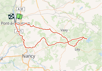

Lengte
147 km

Max. hoogte
333 m

Positief hoogteverschil
1517 m
Km-Effort
167 km

Min. hoogte
176 m

Negatief hoogteverschil
1517 m
Boucle
Ja
Datum van aanmaak :
2019-01-15 13:08:08.899
Laatste wijziging :
2019-01-15 13:08:08.899
5h00
Moeilijkheid : Medium

Gratisgps-wandelapplicatie
 SityTrail
IGN / Geografische instituten
SityTrail Plus
De wereld gaat voor u open
Over ons
Tocht Fiets van 147 km beschikbaar op Grand Est, Meurthe-et-Moselle, Pont-à-Mousson. Deze tocht wordt voorgesteld door PhilippeC54.
Beschrijving
Openrunner #8578308
Plaatsbepaling
Land:
France
Regio :
Grand Est
Departement/Provincie :
Meurthe-et-Moselle
Gemeente :
Pont-à-Mousson
Locatie:
Unknown
Vertrek:(Dec)
Vertrek:(UTM)
284245 ; 5420940 (32U) N.
Opmerkingen