


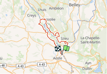
St Genix - Groslée

leeho
Gebruiker

Lengte
53 km

Max. hoogte
239 m

Positief hoogteverschil
372 m
Km-Effort
58 km

Min. hoogte
202 m

Negatief hoogteverschil
372 m
Boucle
Ja
Datum van aanmaak :
2019-01-15 14:29:42.521
Laatste wijziging :
2019-01-15 14:29:42.521
3h27
Moeilijkheid : Gemakkelijk

Gratisgps-wandelapplicatie
 SityTrail
IGN / Geografische instituten
SityTrail Plus
De wereld gaat voor u open
Over ons
Tocht Fiets van 53 km beschikbaar op Auvergne-Rhône-Alpes, Isère, Aoste. Deze tocht wordt voorgesteld door leeho.
Beschrijving
De St Genix-sur-Guiers à Groslée en VAE
Plaatsbepaling
Land:
France
Regio :
Auvergne-Rhône-Alpes
Departement/Provincie :
Isère
Gemeente :
Aoste
Locatie:
Unknown
Vertrek:(Dec)
Vertrek:(UTM)
705042 ; 5052634 (31T) N.
Opmerkingen