


Pacé - La Foucherais

nolsim
Gebruiker
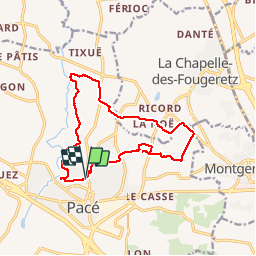

Lengte
13,6 km

Max. hoogte
66 m

Positief hoogteverschil
117 m
Km-Effort
15,2 km

Min. hoogte
34 m

Negatief hoogteverschil
120 m
Boucle
Ja
Datum van aanmaak :
2018-08-18 14:06:37.267
Laatste wijziging :
2018-08-18 14:06:37.267
2h48
Moeilijkheid : Gemakkelijk

Gratisgps-wandelapplicatie
 SityTrail
IGN / Geografische instituten
SityTrail Plus
De wereld gaat voor u open
Over ons
Tocht Stappen van 13,6 km beschikbaar op Bretagne, Ille-et-Vilaine, Pacé. Deze tocht wordt voorgesteld door nolsim.
Plaatsbepaling
Land:
France
Regio :
Bretagne
Departement/Provincie :
Ille-et-Vilaine
Gemeente :
Pacé
Locatie:
Unknown
Vertrek:(Dec)
Vertrek:(UTM)
591351 ; 5334041 (30U) N.
Opmerkingen