


L'ECOLE DES LAVOIRS ET DES MOULINS

NUITEVEN
Gebruiker
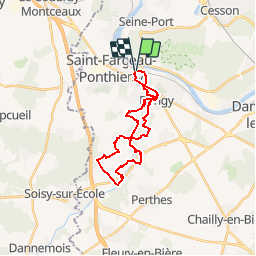

Lengte
21 km

Max. hoogte
88 m

Positief hoogteverschil
283 m
Km-Effort
25 km

Min. hoogte
41 m

Negatief hoogteverschil
283 m
Boucle
Ja
Datum van aanmaak :
2018-09-09 16:06:08.492
Laatste wijziging :
2018-09-09 16:06:08.492
5h33
Moeilijkheid : Heel gemakkelijk

Gratisgps-wandelapplicatie
 SityTrail
IGN / Geografische instituten
SityTrail Plus
De wereld gaat voor u open
Over ons
Tocht Stappen van 21 km beschikbaar op Île-de-France, Seine-et-Marne, Saint-Fargeau-Ponthierry. Deze tocht wordt voorgesteld door NUITEVEN.
Plaatsbepaling
Land:
France
Regio :
Île-de-France
Departement/Provincie :
Seine-et-Marne
Gemeente :
Saint-Fargeau-Ponthierry
Locatie:
Unknown
Vertrek:(Dec)
Vertrek:(UTM)
466410 ; 5375829 (31U) N.
Opmerkingen