


trail sympa

guariso
Gebruiker

Lengte
21 km

Max. hoogte
178 m

Positief hoogteverschil
238 m
Km-Effort
25 km

Min. hoogte
105 m

Negatief hoogteverschil
236 m
Boucle
Ja
Datum van aanmaak :
2018-09-22 21:35:53.911
Laatste wijziging :
2018-09-22 21:35:53.911
1h32
Moeilijkheid : Medium

Gratisgps-wandelapplicatie
 SityTrail
IGN / Geografische instituten
SityTrail Plus
De wereld gaat voor u open
Over ons
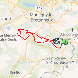
Tocht Mountainbike van 21 km beschikbaar op Île-de-France, Yvelines, Magny-les-Hameaux. Deze tocht wordt voorgesteld door guariso.
Beschrijving
Singles quelques montées pas trop dures quelques descentes techniques... Bref sympa
Plaatsbepaling
Land:
France
Regio :
Île-de-France
Departement/Provincie :
Yvelines
Gemeente :
Magny-les-Hameaux
Locatie:
Unknown
Vertrek:(Dec)
Vertrek:(UTM)
432444 ; 5397105 (31U) N.
Opmerkingen