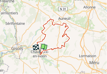
De Chaumont en Vexin au bois de Vilotran

tracegps
Gebruiker


2h30
Moeilijkheid : Medium

Gratisgps-wandelapplicatie
 SityTrail
IGN / Geografische instituten
SityTrail Plus
De wereld gaat voor u open
Over ons
Tocht Mountainbike van 53 km beschikbaar op Hauts-de-France, Oise, Chaumont-en-Vexin. Deze tocht wordt voorgesteld door tracegps.
Beschrijving
Le 55km organisé par Chaumont le 08/06/2008. Départ de Chaumont en direction de la Houssoye pour rejoindre le bois de Vilotran et retour via Fresneaux-Montchevreuil. Parcours roulant sans grandes difficultés.
Plaatsbepaling
Opmerkingen