


Huy Marchin Hiy

ochelen
Gebruiker
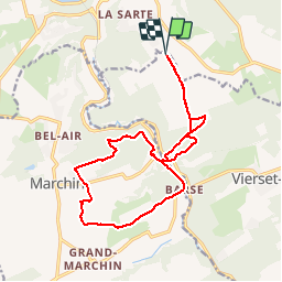

Lengte
15,2 km

Max. hoogte
267 m

Positief hoogteverschil
351 m
Km-Effort
19,9 km

Min. hoogte
132 m

Negatief hoogteverschil
351 m
Boucle
Ja
Datum van aanmaak :
2019-01-15 17:48:36.973
Laatste wijziging :
2019-01-15 17:48:36.973
3h53
Moeilijkheid : Medium

Gratisgps-wandelapplicatie
 SityTrail
IGN / Geografische instituten
SityTrail Plus
De wereld gaat voor u open
Over ons
Tocht Stappen van 15,2 km beschikbaar op Wallonië, Luik, Hoei. Deze tocht wordt voorgesteld door ochelen.
Beschrijving
balade bois et chemin
Plaatsbepaling
Land:
Belgium
Regio :
Wallonië
Departement/Provincie :
Luik
Gemeente :
Hoei
Locatie:
Huy
Vertrek:(Dec)
Vertrek:(UTM)
660287 ; 5597339 (31U) N.
Opmerkingen