![](/images/other/stat-length.png)
![Tocht Stappen Lapoutroie - Traversée des Vosges - le Devin - Le Hohneck - Photo](https://media.geolcdn.com/t/1900/400/ext.pjpeg?maxdim=2&url=https%3A%2F%2Fservices.sitytrail.com%2FGeolivesWS%2FDownloadMedia.ashx%3FTrailID%3D105830%26Media%3D9788_2.jpg)
Traversée des Vosges - le Devin - Le Hohneck
tracegps
Gebruiker
![Lengte](/images/other/stat-length.png)
Lengte
21 km
![Max. hoogte](https://static1.geolcdn.com/siteimages/upload/files/1508320355ic_sort_altitude_max_24dp.png)
Max. hoogte
1352 m
![Positief hoogteverschil](https://static1.geolcdn.com/siteimages/upload/files/1508320355ic_sort_den_pos_24dp.png)
Positief hoogteverschil
933 m
![Km-Effort](/images/other/stat-length.png)
Km-Effort
33 km
![Min. hoogte](https://static1.geolcdn.com/siteimages/upload/files/1508320355ic_sort_altitude_min_24dp.png)
Min. hoogte
933 m
![Negatief hoogteverschil](https://static1.geolcdn.com/siteimages/upload/files/1508320355ic_sort_den_neg_24dp.png)
Negatief hoogteverschil
636 m
![Boucle](https://static1.geolcdn.com/siteimages/upload/files/16400158638029165_repeat_loop_refresh_sync_direction_icon.png)
Boucle
Neen
Datum van aanmaak :
2014-12-10 00:00:00.0
Laatste wijziging :
2014-12-10 00:00:00.0
![Stappen](https://static1.geolcdn.com/sitytour/trail-icons/101.png)
6h30
Moeilijkheid : Moeilijk
![Scan deze QR-code om de tocht te openen in de SityTrail-applicatie](https://capi.geolives.com/qq0zvz2zws4bq2lad0pu/sitytour/trails/105830/qr.png?size=200)
Gratisgps-wandelapplicatie
Over ons
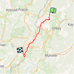
Tocht Stappen van 21 km beschikbaar op Grand Est, Haut-Rhin, Lapoutroie. Deze tocht wordt voorgesteld door tracegps.
Beschrijving
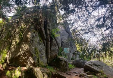
Par les ouvrages militaires comme la Tête des Faux, le cimetière Duchesne, le Col du Calvaire, au dessus du Lac Blanc et le Col de la Schlucht.
Plaatsbepaling
Land:
France
Regio :
Grand Est
Departement/Provincie :
Haut-Rhin
Gemeente :
Lapoutroie
Locatie:
Unknown
Vertrek:(Dec)
Vertrek:(UTM)
360745 ; 5335983 (32U) N.
Opmerkingen
Wandeltochten in de omgeving
![Tocht Stappen Orbey - Le Tour du Lac Blanc par le Rocher Hans et le sentier de crête - Photo](https://media.geolcdn.com/t/375/260/ext.jpg?maxdim=2&url=https%3A%2F%2Fservices.sitytrail.com%2FGeolivesWS%2FDownloadMedia.ashx%3FTrailID%3D112616%26Media%3D11189_5.jpg)
![Stappen Stappen](https://static1.geolcdn.com/sitytour/trail-icons/101.png)
Le Tour du Lac Blanc par le Rocher Hans et le sentier de crête
Stappen
Moeilijk
(3)
Orbey,
Grand Est,
Haut-Rhin,
France
![](/images/other/stat-length.png)
4,4 km | 7,7 km-effort
2h 30min
![](https://static1.geolcdn.com/siteimages/upload/files/16400158638029165_repeat_loop_refresh_sync_direction_icon.png)
Ja
![Tocht Stappen Le Bonhomme - Tête des faux . - Photo](https://media.geolcdn.com/t/375/260/ext.jpg?maxdim=2&url=https%3A%2F%2Fmedia.geolcdn.com%2Ff%2F84fec98d-7f8b-4bf8-a434-52c0363ad440.jpg)
![Stappen Stappen](https://static1.geolcdn.com/sitytour/trail-icons/101.png)
Tête des faux .
Stappen
Medium
(1)
Le Bonhomme,
Grand Est,
Haut-Rhin,
France
![](/images/other/stat-length.png)
11,9 km | 16,6 km-effort
3h 46min
![](https://static1.geolcdn.com/siteimages/upload/files/16400158638029165_repeat_loop_refresh_sync_direction_icon.png)
Ja
![Tocht Stappen Lapoutroie - 2012-06-16 Marche aux Alisiers Orbey - Photo](https://media.geolcdn.com/t/375/260/ext.jpg?maxdim=2&url=https%3A%2F%2Fstatic1.geolcdn.com%2Fsiteimages%2Fupload%2Ffiles%2F1553511878bg_sport_marche.png)
![Stappen Stappen](https://static1.geolcdn.com/sitytour/trail-icons/101.png)
2012-06-16 Marche aux Alisiers Orbey
Stappen
Gemakkelijk
(2)
Lapoutroie,
Grand Est,
Haut-Rhin,
France
![](/images/other/stat-length.png)
11,1 km | 16,6 km-effort
2h 49min
![](https://static1.geolcdn.com/siteimages/upload/files/16400158638029165_repeat_loop_refresh_sync_direction_icon.png)
Ja
![Tocht Mountainbike Orbey - Lac Blanc - Têtes des Faux - Photo](https://media.geolcdn.com/t/375/260/ext.jpg?maxdim=2&url=https%3A%2F%2Fservices.sitytrail.com%2FGeolivesWS%2FDownloadMedia.ashx%3FTrailID%3D101197%26Media%3D684_1.jpg)
![Mountainbike Mountainbike](https://static1.geolcdn.com/sitytour/trail-icons/202.png)
Lac Blanc - Têtes des Faux
Mountainbike
Medium
(1)
Orbey,
Grand Est,
Haut-Rhin,
France
![](/images/other/stat-length.png)
15,3 km | 21 km-effort
1h 0min
![](https://static1.geolcdn.com/siteimages/upload/files/16400158638029165_repeat_loop_refresh_sync_direction_icon.png)
Ja
![Tocht Stappen Le Bonhomme - Le Bonhomme - Circuit du village - Photo](https://media.geolcdn.com/t/375/260/ext.jpg?maxdim=2&url=https%3A%2F%2Fstatic1.geolcdn.com%2Fsiteimages%2Fupload%2Ffiles%2F1553511878bg_sport_marche.png)
![Stappen Stappen](https://static1.geolcdn.com/sitytour/trail-icons/101.png)
Le Bonhomme - Circuit du village
Stappen
Gemakkelijk
(1)
Le Bonhomme,
Grand Est,
Haut-Rhin,
France
![](/images/other/stat-length.png)
3 km | 5,3 km-effort
1h 30min
![](https://static1.geolcdn.com/siteimages/upload/files/16400158638029165_repeat_loop_refresh_sync_direction_icon.png)
Ja
![Tocht Stappen Orbey - 2022-07-23 Marche Lacs Blanc Noir Forlet - Photo](https://media.geolcdn.com/t/375/260/ext.jpg?maxdim=2&url=https%3A%2F%2Fmedia.geolcdn.com%2Ff%2F67d2c05f-be86-4c5f-9cd9-6a9a44ab70e0.jpg)
![Stappen Stappen](https://static1.geolcdn.com/sitytour/trail-icons/101.png)
2022-07-23 Marche Lacs Blanc Noir Forlet
Stappen
Medium
Orbey,
Grand Est,
Haut-Rhin,
France
![](/images/other/stat-length.png)
16,2 km | 26 km-effort
5h 57min
![](https://static1.geolcdn.com/siteimages/upload/files/16400158638029165_repeat_loop_refresh_sync_direction_icon.png)
Ja
![Tocht Stappen Sainte-Marie-aux-Mines - 2021-02-14 Marche Bagenelles Brezouard Fuste de Etoile - Photo](https://media.geolcdn.com/t/375/260/ext.jpg?maxdim=2&url=https%3A%2F%2Fmedia.geolcdn.com%2Ff%2F79d211e6-ae5a-4d3f-8163-d2103469db38.jpg)
![Stappen Stappen](https://static1.geolcdn.com/sitytour/trail-icons/101.png)
2021-02-14 Marche Bagenelles Brezouard Fuste de Etoile
Stappen
Zeer moeilijk
Sainte-Marie-aux-Mines,
Grand Est,
Haut-Rhin,
France
![](/images/other/stat-length.png)
17,1 km | 27 km-effort
6h 6min
![](https://static1.geolcdn.com/siteimages/upload/files/16400158638029165_repeat_loop_refresh_sync_direction_icon.png)
Ja
![Tocht Stappen Lapoutroie - 2020-07-19 Marche Étang du Devin Col Calvaire Tête des Faux - Photo](https://media.geolcdn.com/t/375/260/ext.jpg?maxdim=2&url=https%3A%2F%2Fmedia.geolcdn.com%2Ff%2F615f03a1-e6aa-4706-9550-1df8400dcef8.jpg)
![Stappen Stappen](https://static1.geolcdn.com/sitytour/trail-icons/101.png)
2020-07-19 Marche Étang du Devin Col Calvaire Tête des Faux
Stappen
Heel gemakkelijk
Lapoutroie,
Grand Est,
Haut-Rhin,
France
![](/images/other/stat-length.png)
14,2 km | 22 km-effort
3h 27min
![](https://static1.geolcdn.com/siteimages/upload/files/16400158638029165_repeat_loop_refresh_sync_direction_icon.png)
Ja
![Tocht Stappen Orbey - Orbey-Labaroche - Photo](https://media.geolcdn.com/t/375/260/ext.jpg?maxdim=2&url=https%3A%2F%2Fstatic1.geolcdn.com%2Fsiteimages%2Fupload%2Ffiles%2F1553511878bg_sport_marche.png)
![Stappen Stappen](https://static1.geolcdn.com/sitytour/trail-icons/101.png)
Orbey-Labaroche
Stappen
Gemakkelijk
(1)
Orbey,
Grand Est,
Haut-Rhin,
France
![](/images/other/stat-length.png)
13,7 km | 21 km-effort
4h 17min
![](https://static1.geolcdn.com/siteimages/upload/files/16400158638029165_repeat_loop_refresh_sync_direction_icon.png)
Ja