Tocht Mountainbike Tinchebray-Bocage - Boucle autour de Ger et de ses éoliennes - Photo

Boucle autour de Ger et de ses éoliennes

 tracegps
tracegps

Gebruiker

© OpenStreetMap contributors
Lengte
Lengte
19,9 km
Max. hoogte
Max. hoogte
333 m
Positief hoogteverschil
411 m
Km-Effort
Km-Effort  
25 km
Min. hoogte
Min. hoogte
172 m
Negatief hoogteverschil
410 m
Boucle
Boucle
Ja
Datum van aanmaak :
2014-12-10 00:00:00.0
Laatste wijziging :
2014-12-10 00:00:00.0

(0 Bericht)

Mountainbike
Mountainbike
2h30
Moeilijkheid : Gemakkelijk

Scan deze QR-code om de tocht te openen in de SityTrail-applicatie

Gratisgps-wandelapplicatie

Logo SityTrail SityTrail

IGN / Geografische instituten

SityTrail uit de App Store downloaden SityTrail uit Google Play downloaden

Logo SityTrail SityTrail World

De wereld gaat voor u open

SityTrail uit de App Store downloaden SityTrail uit Google Play downloaden SityTrail op Huawei AppGallery downloaden

Over ons

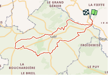
Tocht Mountainbike van 19,9 km beschikbaar op Normandië, Orne, Tinchebray-Bocage. Deze tocht wordt voorgesteld door tracegps.

Beschrijving

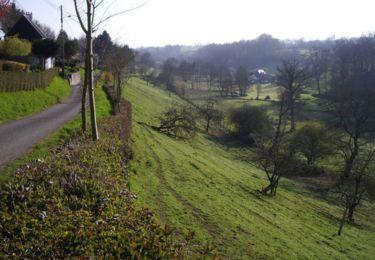
Cette boucle autour de Ger se fait sans difficultés. La seule montée du parcours se faisant sur route. Par contre, en hiver, les chemins peuvent être détrempés et on se fatigue plus à piloter le vélo qu'à le faire grimper ou avancer. Sinon, passages sympas dans des chemins longeant des ruisseaux.

Hoogteprofiel

Plaatsbepaling

Land:
France
Regio :
Normandië
Departement/Provincie :
Orne
Gemeente :
Tinchebray-Bocage
Locatie:
Beauchêne
Vertrek:(Dec)
Vertrek:(UTM)
665853 ; 5395932 (30U) N.

Wandeltochten in de omgeving

Tocht Stappen Tinchebray-Bocage - Chemin de l'Egrenne (n° 9) - Beauchêne  - Photo
Stappen
tracegps

Stappen

Medium
(1)
Tinchebray-Bocage, Normandië, Orne, France
11,2 km | 14,6 km-effort
2h 49min
Ja
Tocht Te voet Tinchebray-Bocage - Le Ruslé - Photo
Te voet
PRO

Te voet

Gemakkelijk
Tinchebray-Bocage, Normandië, Orne, France
5,4 km | 6,9 km-effort
1h 34min
Neen
Tocht Stappen Tinchebray-Bocage - Michelot Moulin - Pays de Tinchebray - Photo
Stappen
tracegps

Stappen

Medium
Tinchebray-Bocage, Normandië, Orne, France
12,4 km | 15,4 km-effort
3h 0min
Ja
Tocht Te voet Tinchebray-Bocage - Chemin de l'Egrenne - Photo
Te voet
PRO

Te voet

Gemakkelijk
Tinchebray-Bocage, Normandië, Orne, France
10,6 km | 14 km-effort
3h 10min
Ja
Tocht Stappen Tinchebray-Bocage - Le Ruslé  (n° 11)  - Yvrandes - Photo
Stappen
tracegps

Stappen

Gemakkelijk
Tinchebray-Bocage, Normandië, Orne, France
5,7 km | 7,3 km-effort
1h 30min
Ja
Tocht Mountainbike Tinchebray-Bocage - Vente Roulleaux, Le Tertre, Lonlay l'Abbaye - Photo
Mountainbike
tracegps

Mountainbike

Medium
Tinchebray-Bocage, Normandië, Orne, France
25 km | 32 km-effort
1h 55min
Neen
Tocht Mountainbike Tinchebray-Bocage - Ger, Saint Jean des Bois, Yvrandes, Les Trois Cheminées - Photo
Mountainbike
tracegps

Mountainbike

Medium
Tinchebray-Bocage, Normandië, Orne, France
21 km | 27 km-effort
2h 30min
Ja
Tocht Mountainbike Tinchebray-Bocage - Vente Roulleaux, Saint Jean des Bois, Le Fresne Poret - Photo
Mountainbike
tracegps

Mountainbike

Medium
Tinchebray-Bocage, Normandië, Orne, France
22 km | 27 km-effort
1h 49min
Ja
Tocht Stappen Tinchebray-Bocage - Petiteboucle à pied - La Vente Roulleau - Photo
Stappen
tracegps

Stappen

Medium
Tinchebray-Bocage, Normandië, Orne, France
3,1 km | 4,4 km-effort
30min
Ja


Sluiten
Mijn abonnementen