


st aubin des Hayes

werth
Gebruiker
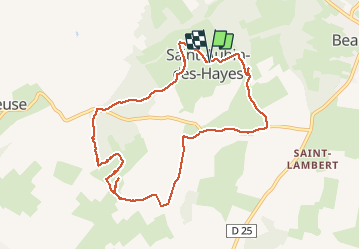

Lengte
9,1 km

Max. hoogte
176 m

Positief hoogteverschil
59 m
Km-Effort
9,8 km

Min. hoogte
149 m

Negatief hoogteverschil
59 m
Boucle
Ja
Datum van aanmaak :
2019-01-15 18:30:06.323
Laatste wijziging :
2019-01-15 18:30:06.323
2h39
Moeilijkheid : Gemakkelijk

Gratisgps-wandelapplicatie
 SityTrail
IGN / Geografische instituten
SityTrail Plus
De wereld gaat voor u open
Over ons
Tocht Stappen van 9,1 km beschikbaar op Normandië, Eure, Mesnil-en-Ouche. Deze tocht wordt voorgesteld door werth.
Beschrijving
Très jolie
Plaatsbepaling
Land:
France
Regio :
Normandië
Departement/Provincie :
Eure
Gemeente :
Mesnil-en-Ouche
Locatie:
Unknown
Vertrek:(Dec)
Vertrek:(UTM)
330261 ; 5431036 (31U) N.
Opmerkingen